SOUTH
SOUTH Marine Division, specializing in hydrography and marine survey, is actually a subsidiary of SOUTH Survey Group, a leading Chinese giant manufacturer in the geo-spatial industry. With 35 years of...

SOUTH Marine Division, specializing in hydrography and marine survey, is actually a subsidiary of SOUTH Survey Group, a leading Chinese giant manufacturer in the geo-spatial industry. With 35 years of...
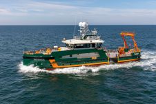
The N-Sea Group has formalized an agreement with Geo Plus for the long-term charter of the Dutch-flagged vessel the Geo Ranger, a cutting-edge hybrid survey and ROV support vessel. This...

Through the collaborative implementation of satellite-derived bathymetry (SDB), the Danish Geodata Agency and EOMAP are synergizing efforts to contribute to the European Marine Observation and Data Network (EMODnet) Bathymetry partnership....

When contemplating the replacement of a research and survey fleet, a collective effort is required to meticulously curate an optimal new fleet, considering factors such as ship type, size, capabilities...
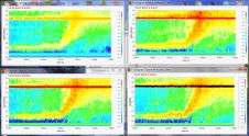
Laboratory experiments were carried out in July 2018 with ASL Environmental Sciences' multi-frequency Acoustic Zooplankton Fish Profiler (AZFP) at the Bureau of Safety and Environmental Enforcement's Ohmsett Oil Spill Response Research...

The development of unmanned and autonomous surface vehicles in recent years has triggered a new era in civilian and military maritime operations. One of the applications that is likely to...
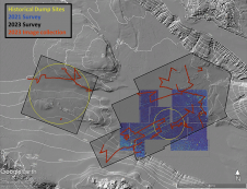
In a second seafloor survey off the Southern California coast, researchers from UC San Diego’s Scripps Institution of Oceanography uncovered a staggering 350 square kilometres of discarded military munitions. The April...
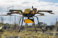
YellowScan, a familiar name in the mapping and land surveying realm, is making a noteworthy entrance in the hydrographic sector with the introduction of its pioneering UAV-based bathymetric Lidar solution....
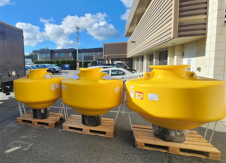
ASL recently acquired three Mesemar PBM-15 polyethylene buoys for a major metocean study being undertaken as part of a client project. These buoys adhere to the recommendations of the International...
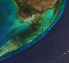
The Florida Department of Environmental Protection has commissioned Woolpert to acquire bathymetric survey data using Lidar technologies to support the Florida Seafloor Mapping Initiative (FSMI) and its mission to produce...
This site uses cookies. By continuing to use this website, you agree to our Cookies Policy. Agree