SeaRobotics Corporation
SeaRobotics Corporation was formed in 1999 to commercialise technology developed by the US Navy’s Office of Naval Research (ONR). After working with Autonomous Underwater Vehicle (AUV) technology and developing numerous...
SeaRobotics Corporation was formed in 1999 to commercialise technology developed by the US Navy’s Office of Naval Research (ONR). After working with Autonomous Underwater Vehicle (AUV) technology and developing numerous...
De Beers Marine routinely acquires ultra high-resolution geophysical data in support of its offshore mining and exploration programmes for diamondiferous placer deposits situated on the continental shelf off the West...
Since its introduction many years ago, survey sonar has evolved steadily, but is still a difficult and non-intuitive survey tool, requiring large amounts of processing to arrive at the most...
The coastal zone of Nigeria has in recent years been subjected to increasing economic activities, primarily driven by seaport activities and oil exploration and exploitation. These activities have reportedly resulted...
On July 5th 2003 the Maritime Museum of the Atlantic, the Canadian Hydrographic Service and former officers, staff and crew of the CSS Acadia, gathered in Halifax, Nova Scotia, to...
An electronic chart system, whether an Electronic Chart Display and Information System (ECDIS) or an Electronic Chart System (ECS), is primarily designed for safe navigation. But its ability to display...
The Port Authorities in China want to adopt as standard in ports and harbours the navigable water depth; many ports in China have a problem with silt, liquid mud, deposited...
For attaining high-resolution echo-prints, echosounding equipment must fulfil certain requirements regarding directivity, pulse length and other properties possible to achieve using non-linear acoustics. One important problem in sediment acoustics is...
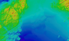
In early 2001, BP Exploration and Production, and Shell International and Production contracted C&C Technologies Inc. to conduct a marine survey for the proposed Okeanos Gas Pipeline route, using their...
Hydrographers require accurate three-dimensional positions of the survey vessel and typically use differing methods for resolving the horizontal and vertical components. GNSS, such as the Navstar Global Positioning System (GPS),...
This site uses cookies. By continuing to use this website, you agree to our Cookies Policy. Agree