Japan launches project to map 90% of coastal waters
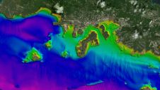
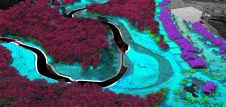
The ‘Umi-no-Chizu’ (‘Map of the Sea’) project will use aerial measurement to map 90% of Japan’s shallow coastal waters (to a depth of 20m). This is a joint project by...
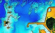
The ‘Umi-no-Chizu’ (‘Map of the Sea’) project will use aerial measurement to map 90% of Japan’s shallow coastal waters (to a depth of 20m). This is a joint project by...

Woolpert sports an innovative and agile team of certified hydrographers, professional land surveyors and GIS professionals. This industry-leading crew develops and integrates topographic, bathymetric and hydrographic technologies to provide clients...

Saildrone has been selected to receive a major award from the National Offshore Wind Research and Development Consortium (NOWRDC) to facilitate offshore wind’s coexistence with wildlife and other ocean users....
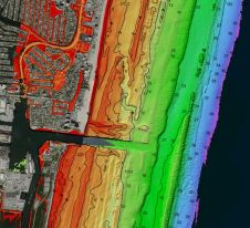
Since the 1970s, remote sensing has increasingly been used to conduct underwater surveys. Several methodologies are employed in hydrographic surveying, from direct techniques such as probing rods to more sophisticated...
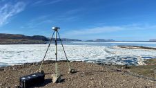
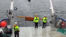
Researchers from the Bureau of Economic Geology have spent the summer in northwestern Greenland conducting research using an airborne Lidar system. The project – Airborne Lidar surveys to quantify Greenland...
“Think big for coastal mapping” is the foremost advice that Don Ventura of Teledyne Geospatial would impress upon agencies interested in bathymetric Lidar. “It’s a matter of efficiency of scale.”...
In this edition of our Q&A series with leading experts from the hydrographic industry, Paul Seaton of Fugro shares his thoughts on a variety of topics, such as key market...

Woolpert has acquired eTrac, a vessel-based hydrographic survey and marine technology firm that conducts custom and integrated marine services for projects across the U.S. and its territories. These marine services...
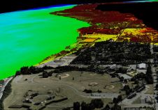
Woolpert has been granted a patent by the United States Patent and Trademark Office for its ‘Airborne Topo-Bathy Lidar System and Methods Thereof’. A Lidar sensor system was developed by...
In our profession, object detection takes the form of hydrographic surveys that are carried out to detect wrecks, anchors, pipelines and ammunition. The latter is better known as UXO surveys,...
This site uses cookies. By continuing to use this website, you agree to our Cookies Policy. Agree