Welcome to the New Geospatial
Teledyne Optech and Teledyne CARIS have united to form Teledyne Geospatial in response to evolving marketplace needs. Under the Teledyne Imaging group, the harmony between the two business units is...
Teledyne Optech and Teledyne CARIS have united to form Teledyne Geospatial in response to evolving marketplace needs. Under the Teledyne Imaging group, the harmony between the two business units is...
The International Federation of Hydrographic Societies (IFHS) has developed the Hydrographic Professional Accreditation Scheme (HPAS) to provide international recognition to hydrographic professionals in demonstrating their competency, educational background and career development. The HPAS initiative has reached an important milestone by completing its Pilot Phase, which was...

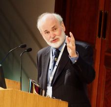
Guillaume Eudeline joined iXblue in 2017, after a first 17-year career as a Naval Officer in the French Navy and a two-year experience as sales manager in the naval domain....
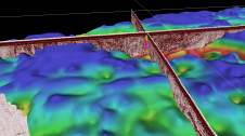
In 2021, five Norwegian and international companies decided to join forces to support the development of software that can be used to interpret seabed and subsurface ground conditions and visualize the results. The...

Hydro International spoke to five leading experts about the present and future of the hydrographic industry. In this interview, Birte Noer Borrevik (Kartverket: the Norwegian Mapping Authority) talks about big...
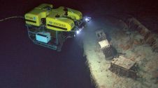
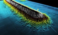
In the night of 14 April 1912, the unthinkable happened. The mightiest ship afloat, the brand new White Star Line ship Titanic, was on its maiden voyage from Southampton, England,...
The new Gwyn Griffiths Underwater Robotics Award was one of the announcements made at the Society for Underwater Technology’s (SUT’s) Annual General Meeting by the new President of Council, Judith...

Hydro International spoke to five leading experts about the present and future of the hydrographic industry. In this interview, Eric Langlois (International Federation of Hydrographic Societies) focuses on the next...

Rachel Bobich is a hydrographer and the proprietor of RMB GEO, a marine and data science firm. She specializes in hydrospatial mapping techniques such as topobathy Lidar and satellite-derived bathymetry,...

During his military career, he was the senior policy lead negotiating the shared objectives for the Allied System for Geospatial Intelligence (ASG), a geospatial intelligence burden-sharing collaboration between the US,...
This site uses cookies. By continuing to use this website, you agree to our Cookies Policy. Agree