Andrijana Horvat
Andrijana Horvat is R&D lead geophysicist and GIS specialist at Hidrocibalae, with a Master’s in Geography from the University of Zagreb. Her professional interests include hydrography, GIS, Python programming and cartography,...
Andrijana Horvat is R&D lead geophysicist and GIS specialist at Hidrocibalae, with a Master’s in Geography from the University of Zagreb. Her professional interests include hydrography, GIS, Python programming and cartography,...
Srećko Kajić is reporting lead and GIS engineer at Hidrocibalae, with a Master’s in Geography from the University of Zagreb. His professional interests include GIS, cartography, hydrography and spatial planning,...

Julià Talaya holds a PhD in Applied Mathematics. He has worked for ICGC for 32 years in various management roles, including GNSS positioning, aerial surveys, remote sensing and cartography. He...

Charles de Jongh holds an MSc in cartography and geographical information science. He has 20 years of experience in the marine geospatial field, including several roles at software company CARIS...
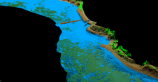
As part of a Catalan government project to improve the management of its marine environment, ICGC cooperated with Field to use airborne Lidar bathymetry (ALB) to survey the Catalan coastal...
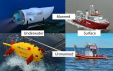
The life of a hydrographic planner used to be easy: you had a survey vessel from which (at least in nautical cartography) you deployed a number of survey boats (often...
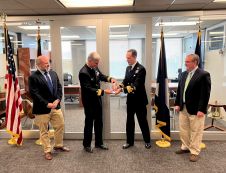
The UK Hydrographic Office (UKHO) has presented the 2021 Alexander Dalrymple Award to the U.S. Office of Coast Survey (OCS) in recognition of its outstanding contribution to global hydrography. UK...
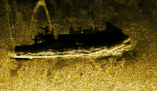
The mysterious Black Sea has many secrets yet to be discovered. This research presents the results of the biggest UXO survey project performed on the Romanian Black Sea coast after...

Jacek Łubczonek conducts research on hydrographic and topographic data processing using geoinformatics techniques and artificial intelligence methods at the Maritime University of Szczecin, Poland. He received a PhD in geodesy...

Witold Kazimierski, navigator and GIS specialist, received a PhD in geodesy and cartography in 2008. He is currently an associate professor at the Maritime University of Szczecin, Poland, and focuses...
This site uses cookies. By continuing to use this website, you agree to our Cookies Policy. Agree