Tides Database Upgrade for SHOM
A major upgrade of CherSoft’s TdB (Tides Database) has been completed by the Service hydrographique et océanographique de la marine (SHOM), France. The upgrade to TdB version 2.5 provides a...
A major upgrade of CherSoft’s TdB (Tides Database) has been completed by the Service hydrographique et océanographique de la marine (SHOM), France. The upgrade to TdB version 2.5 provides a...
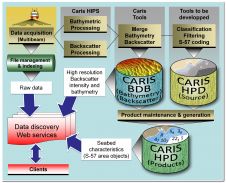
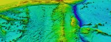
The Canadian Hydrographic Service (CHS) is willing to make better use of the backscatter intensity data collected with their multibeam sounding systems. All the backscatter data collected during the last...
Marine Regions, an online standard list of georeferenced marine place names, areas, regions, marine and maritime boundaries, has been launched. It is an integration of the VLIMAR Gazetteer and the...

During Ocean Business, CARIS officially launched and demoed the new version of Bathy DataBase 3.1 which as a new feature supports Oracle 11g. Delegates interested to see the new development...
The latest release Bathy DataBASE 3.1 from CARIS now works with Oracle Spatial 11g, utilising the GeoRaster and geo point-cloud data structures for storage. Oracle Spatial has been specifically designed...
Project team members EDS, CARIS and LSC Group are proud to announce the final acceptance by the United Kingdom Hydrographic Office (UKHO) of the Hydrographic Database (HDB) Project. Through the...
The UK Hydrographic Office's Admiralty ENC and ECDIS services continue their major expansion with over 6,500 ENC cells now available worldwide and with a further 1,000 cells scheduled to be...
The 11th Edition of the Global Maritime Boundaries Database, or "GMBD," provides a concise, GIS-based, research tool containing the current state of global maritime claims, boundaries and related information mined...
The American National Standards Institute (ANSI) has published the ECS Database standard, ISO 19379 and this is now available for purchase. In the United States copies of this copyright document...
ARGANS, a leading Earth observation company, has contributed a significant dataset of 8,000 square kilometres to The Nippon Foundation-GEBCO Seabed 2030 Project – the project seeking to inspire the complete...
This site uses cookies. By continuing to use this website, you agree to our Cookies Policy. Agree