UKHO Hydrographic Database Solution
EDS, as a prime contractor, and CARIS, as the sub-contractorhave been selected for the United Kingdom Hydrographic Office (UKHO) Hydrographic Database (HDB) Project. Through the HDB Project, EDS and CARIS...
EDS, as a prime contractor, and CARIS, as the sub-contractorhave been selected for the United Kingdom Hydrographic Office (UKHO) Hydrographic Database (HDB) Project. Through the HDB Project, EDS and CARIS...
McDonald Bradley has recently won an US$11.2 million prime contract with the National Oceanic and Atmospheric Agency (NOAA) to develop the Nautical Charting System II – an enterprise solution for...
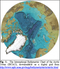
Bathymetric mapping remains incomplete in the Arctic and Southern Oceans. Some proposed International Polar Year activities could help improve the situation by collecting new soundings during vessel transits to and...
Monfils, R., Gilbert, T. and Nawadra S., 2006.Ocean & Coastal Management Selected Papers from the East Asian Seas Congress 2003, Putrajaya, Malaysia, 49: pp 779-788.Oil, chemicals and unexploded ordinances onboard...

This was the first time CARIS had hosted its International Users Group Conference on 5th -9th March 2007 in Asia. Having delivered the event to various cities in North America...
INDUS has won a contract from the EPA's Office of Water valued in excess of US$10 million dollars over five years. INDUS will provide systems support to key Office of...
ESRI’s Production Line Tool Set (PLTS) for ArcGIS—Nautical Solution 9.2 offers users a database-centric approach to produce and maintain high quality data for analysis and chart production making it easier...
Detailed information and a fundamental understanding of the marine environment will make the difference in operating effective and responsible for-naval purposes. Over the last decade, international developments (such as the...
The UK Environment Agency (EA) has been working with 1Spatial and its system integration partner Scisys to evaluate data re-engineering for the National Flood and Coastal Defence Database (NFCDD) system...
The Hydrography Unit of the MCA's Navigation Safety branch have released a selection of files for download to the general public which provide information regarding some of the MCA's bathymetric...
This site uses cookies. By continuing to use this website, you agree to our Cookies Policy. Agree