Hydro International - September/October 2018
COVER STORY: The front cover of this issue of Hydro International shows the IBCAO grid displaying the Arctic Sea with a black box outlining Chukchi Plateau. The availability of a...
COVER STORY: The front cover of this issue of Hydro International shows the IBCAO grid displaying the Arctic Sea with a black box outlining Chukchi Plateau. The availability of a...
Hydrographic Offices have realised that bathymetric data is not sufficiently represented in Electronic Navigational Charts (ENCs). A few aspects of this topic have already been touched upon in the presentation...

In the article entitled 'How Blockchain Will Have an Impact on Navigation', published in the March/April 2018 issue of Hydro International, Gert Büttgenbach explains how the new blockchain technology could...

1 July 2018 will be a historic date for chart navigation at sea, states Mathias Jonas in a recent article. On exactly this day ECDIS carriage requirement will be mandated for...
By the end of this year, the gap will have finally closed on the mandatory requirements for ships to carry an Electronic Chart Display and Information System (ECDIS), with all...
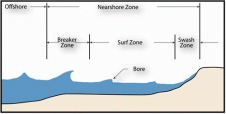
The specific goal of the Digital Elevation Models of Coastal Areas (DEMCA) project is to develop an innovative method to produce seamless digital elevation models of large, flat coastal areas....

Whether you want to launch your new multibeam echosounder, are looking for an outstanding surveyor, aim to strengthen brand recognition or are keen to demonstrate the tangible benefits of your...
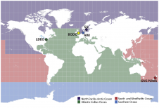
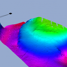
Despite countless days of surveying at sea, we have still mapped less than 20 percent of the world’s oceans. It is time to get organised, according to Rear Adm Shepard...
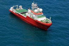
Fugro is leading the marine survey industry in support of NF-GEBCO Seabed 2030, a global initiative to produce a definitive, high-resolution bathymetric map of the entire world’s ocean floor by...
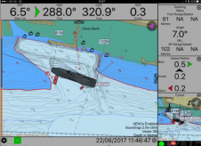
The Israeli Navy Hydrographic Branch (INHB) is transforming itself into a 21st-century organization. Moving away from traditional methods of generating hydrographic products, INHB has adopted geographic information system (GIS) technology....
This site uses cookies. By continuing to use this website, you agree to our Cookies Policy. Agree