Multibeam sonar reveals ship that warned Titanic of icebergs
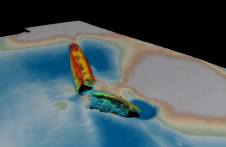
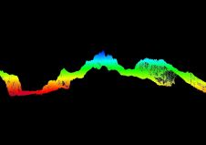
The ship that sent an iceberg warning to the RMS Titanic before the ocean liner sank has been identified in the Irish Sea. Using state-of-the art multibeam sonar, researchers at Bangor...
The ship that sent an iceberg warning to the RMS Titanic before the ocean liner sank has been identified in the Irish Sea. Using state-of-the art multibeam sonar, researchers at Bangor...
Terradepth and The Nippon Foundation-GEBCO Seabed 2030 project are entering a new partnership that will utilize Terradepth’s geospatial data portal known as Absolute Ocean. Seabed 2030 will use Absolute Ocean as...
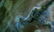
In early 2022, EOMAP started mapping the shallow waters of Belize using SDB technology. Parts of these approximately 9,000 square kilometres had never been sufficiently surveyed before. Now, the bathymetry...
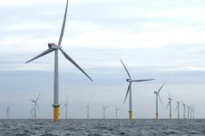
RWE Renewables has appointed ABPmer to support the design of the Awel y Môr Offshore Wind Farm in the Irish Sea. The marine consultancy company is assessing the sediment mobility...
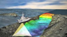
Countless ships and aircraft were lost at sea in the two world wars. Many of these went down with a large amount of fuel and munitions onboard, not to forget...

Jamie McMichael-Phillips is director of The Nippon Foundation-GEBCO Seabed 2030 Project. A hydrographic surveyor and former Royal Navy captain, Jamie has worked in a range of leadership roles, from running...
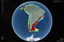
The Nippon Foundation-GEBCO Seabed 2030 Project has just over nine years left to achieve its indispensable goal of the definitive, freely available map of the entire world ocean floor. The...
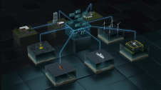
Kongsberg Maritime has announced the launch of Blue Insight, a powerful, cloud-based digital toolbox to enable high-end collection, visualization, contextualization, management and distribution of ocean data. Focusing on marine and...
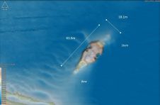
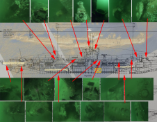
Scientists at Bangor University (Wales) have helped to identify a shipwreck in the middle of the southern Irish Sea, previously thought to be that of a submarine, which has now...
The Nippon Foundation-GEBCO Seabed 2030 Project has entered a technical cooperation agreement with the UK Hydrographic Office (UKHO) and Teledyne CARIS. The Memorandum of Understanding – announced on the first...
This site uses cookies. By continuing to use this website, you agree to our Cookies Policy. Agree