The evolution of Dutch hydrography
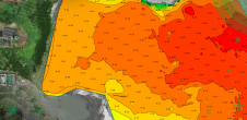
Given the Netherlands’ geographical location, it is unsurprising to find it has a long tradition of hydrography. The lowland, often below sea level, forms a delta where major rivers from...

Given the Netherlands’ geographical location, it is unsurprising to find it has a long tradition of hydrography. The lowland, often below sea level, forms a delta where major rivers from...

How do you perceive prospects in the hydrographic surveying industry in 2024, compared to the past couple of years? When contemplating the hydrographic sector holistically, which areas of investment do...
All over the world, surveyors are opting for UAV technologies to advance coastal mapping services. VBW Weight GmbH from Germany and RASA Surveying from the Philippines are professional service providers...

Ephraim Friedli is an engineering specialist at Axpo Power AG, where he is responsible for bathymetric measurements in the Hydro & Biomass division. He previously worked as a scientific assistant...
The implementation of the new IHO hydrographic geospatial standard for marine data and information, the S-100 product family, presents significant challenges that require coordination between the IHO, the industry involved...

Julià Talaya holds a PhD in Applied Mathematics. He has worked for ICGC for 32 years in various management roles, including GNSS positioning, aerial surveys, remote sensing and cartography. He...
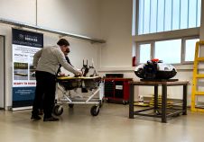
Subsea Europe Services has opened a new R&D centre at its premises in the Ocean Technology Campus Rostock. The new department is led by Frank Niemeyer and has been established...
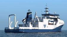
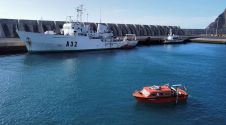
U.S. oceanographic research centre Monterey Bay Aquarium Research Institute (MBARI) has chosen deepwater positioning technology from Sonardyne for its new, state-of-the-art scientific flagship the RV David Packard. The 50 m-long...
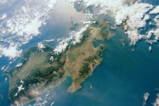
The Nippon Foundation-GEBCO Seabed 2030 Project has entered into a memorandum of understanding with the National Mapping and Resource Information Authority (NAMRIA) of the Philippines. The two parties will work...

Laura Coelho de Andrade is a geomatic engineer. She is a Master’s student in Spatial Information (Geodesy and Hydrography) at the Federal University of Viçosa (UFV). She is also a...
This site uses cookies. By continuing to use this website, you agree to our Cookies Policy. Agree