Lidar in surveying & mapping
Lidar, short for Light Detection and Ranging surveying, represents a sophisticated measuring system leveraging the power of light. Widely recognized for its versatility, Lidar is extensively applied in diverse fields...
Lidar, short for Light Detection and Ranging surveying, represents a sophisticated measuring system leveraging the power of light. Widely recognized for its versatility, Lidar is extensively applied in diverse fields...

Various attempts have recently been made to expand the scope of research in the maritime field through the convergence of cutting-edge technologies. One example is the remote classification and prediction...

Experts are extremely concerned about the temperature of the Pacific Ocean, as the sea surface temperature this year was the warmest since satellite measurements began. This can have major consequences: for...

Andrijana Horvat is R&D lead geophysicist and GIS specialist at Hidrocibalae, with a Master’s in Geography from the University of Zagreb. Her professional interests include hydrography, GIS, Python programming and cartography,...

Srećko Kajić is reporting lead and GIS engineer at Hidrocibalae, with a Master’s in Geography from the University of Zagreb. His professional interests include GIS, cartography, hydrography and spatial planning,...
S. T. Hudson Engineers, Inc. is a pioneer in state-of-the-art marine engineering and total harbour facilities and a specialist in marine technical services. It has provided professional consulting, surveying and engineering...

As Korea officially commemorates Hydrography Day, the Hydrographic Society of Korea (HySK) has acted as a link between industry, academia and research for the past ten years. The Republic of...
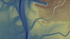
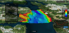
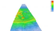
Morro Bay, a shallow coastal estuary located near San Luis Obispo, California, supports an abundance of wildlife and is home to a vibrant outdoor community. However, changes – such as sedimentation...
Positioning, in its essence, represents the meticulous process of accurately determining the spatial location of an object concerning a specific framework or datum. This fundamental concept of positioning plays an...
As the OSIRIS-REx begins its return journey to Earth, Hydro International content manager Wim van Wegen wonders why it is that deep space feels more like home than the deep waters...
This site uses cookies. By continuing to use this website, you agree to our Cookies Policy. Agree