Japan launches project to map 90% of coastal waters
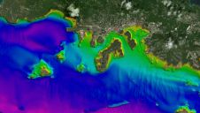
The ‘Umi-no-Chizu’ (‘Map of the Sea’) project will use aerial measurement to map 90% of Japan’s shallow coastal waters (to a depth of 20m). This is a joint project by...
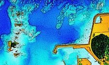
The ‘Umi-no-Chizu’ (‘Map of the Sea’) project will use aerial measurement to map 90% of Japan’s shallow coastal waters (to a depth of 20m). This is a joint project by...
Voyis has announced the development of the IMAGE (Image Mapping & Analysis for Governance and Education) project, funded through Fisheries and Oceans Canada’s Ocean Management Contribution Programme (OMCP). This project will...
Topodrone, a Swiss-based designer and manufacturer of high-precision Lidar equipment for installation on drones, vehicles and backpacks, has launched Aquamapper, a UAV-based solution for bathymetric surveying and marine construction. The...
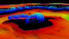
Hydrographers are increasingly aware of the added value that a Lidar (Light Detection and Ranging) scanner can bring to bathymetry survey operations. The Teledyne Optech Polaris Laser Scanner, for example,...
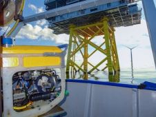
Deutsche Windtechnik has signed several contracts for underwater inspections at offshore wind farms in the North Sea and Baltic Sea. As part of the sustainable, cost-efficient cluster campaign approach, more...
Since the 1970s, remote sensing has increasingly been used to conduct underwater surveys. Several methodologies are employed in hydrographic surveying, from direct techniques such as probing rods to more sophisticated...
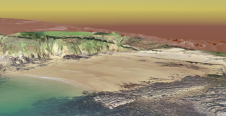
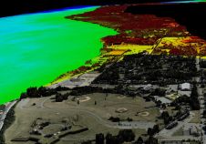
To understand coastal change and anticipate what our future coast will look like, scientists carry out regular field surveys in the form of beach profiles and digital elevation models (DEMs)....
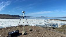
Researchers from the Bureau of Economic Geology have spent the summer in northwestern Greenland conducting research using an airborne Lidar system. The project – Airborne Lidar surveys to quantify Greenland...
A Saab Seaeye deep-rated Falcon robot has been chosen for expedition yacht Dapple as a standby rescue resource for emergency recovery of its manned submersible. In addition, the 1,000 metre-rated Falcon...
“Think big for coastal mapping” is the foremost advice that Don Ventura of Teledyne Geospatial would impress upon agencies interested in bathymetric Lidar. “It’s a matter of efficiency of scale.”...
This site uses cookies. By continuing to use this website, you agree to our Cookies Policy. Agree