UAS at the Beach
The North Sea Canal connects the Port of Amsterdam with the sea. The two breakwaters at the mouth of the harbour in IJmuiden, The Netherlands, are usually monitored on displacement...
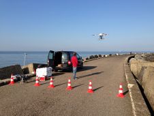
The North Sea Canal connects the Port of Amsterdam with the sea. The two breakwaters at the mouth of the harbour in IJmuiden, The Netherlands, are usually monitored on displacement...
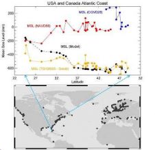
For decades, scientists have disagreed about whether the sea is higher or lower heading north along the east coast of North America. Gravity data from ESA’s GOCE satellite contributed to...

The field of geodesy is undergoing a revolutionary change. The developments of the last few decades have altered the views and work of professional surveyors, researchers and developers immensely, think...
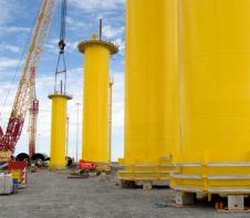
The Dutch company SPT developed a new foundation concept for offshore wind turbines in order to reduce the costs and environmental impact: a Self Installing Wind Turbine. The concept is...

Aberdeen Harbour Board has announced the completion of a GBP4 million refurbishment project at Commercial Quay East, while welcoming the arrival of a new GBP1 million workboat. The Sea Herald,...
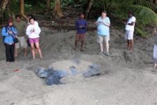
In 2009, a research project was implemented to study the potential socio-economic impacts of climate change upon coastal communities in Canada and the Caribbean. Grande Riviere in Trinidad and Tobago,...
DONG Energy, leading partner in the construction and operational phases of the Walney project, uses Holmatro's aluminium hydraulic cylinders for levelling the foundations of the turbines. So-called transition pieces (TP's)...

BioSonics is to unveil its latest generation of Automated Monitoring Systems at the OCEANS 2010 conference next month. This sonar-based tracking and monitoring system centres around BioSonics focused split-beam hydro-acoustic...
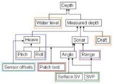
As shipping companies continue to make their operations more cost efficient and environmentally friendly, the demand for high density data has increased. Uncertainty management is a cornerstone to sound Geomatics...
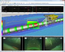
NaviModel software for ocean mapping, data analysis and interpretation provides intuitive 3D visualiasation of infinite survey data sets by import of multiple data formats and sources using user-defined templates. NaviModel...
This site uses cookies. By continuing to use this website, you agree to our Cookies Policy. Agree