ICH Metadata Web Portal Goes Live (5-3-2004)
The Integrated Coastal Hydrography (ICH) project has created a web based portal which allows users to search for information (in the form of metadata – data about data) on existing...
The Integrated Coastal Hydrography (ICH) project has created a web based portal which allows users to search for information (in the form of metadata – data about data) on existing...
In the framework of the EU-financed project EUROSEISMIC a central metadatabase for geophysical data derived from marine seismic surveys for the European Seas has been generated and developed. EUROSEISMIC established...
Laser-Scan has signed a contract with the United Kingdom Hydrographic Office (UKHO), Ministry of Defence, for the support and maintenance of key operational production systems. The contract provides the UKHO...
Land Information New Zealand (LINZ) is the New Zealand Government's steward of authoritative hydrographic information for nautical charts and publications and provides the hydrographic infrastructure to support these services and...
Canadian Hydrographic Service (CHS) recognises the need to improve its processes for data management and product creation to meet the high standards expected by the hydrographic community. From a task...
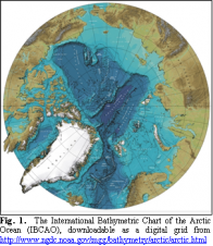
GEBCO uses deepwater survey data to produce bathymetry maps and grids. Published maps appear complete but are in fact based on very little data. Only a portion of the deep...
Navigational safety and political-economic considerations make it essential for port administrations and hydrographic services to have a prioritised survey programme. Finding criteria that reflect the importance of re-survey over a...
The Hydrographic Office (HO) is an important part of the National Geo-Spatial Data Infrastructure and, of course, the International Hydrographic Organization (IHO) has an important role to play in co-ordinating...
Imagine piloting a 398m container ship into port TODAY using an ENC updated with survey data collected YESTERDAY. Isn’t this order of turnaround time the ultimate dream of any ENC...
Bathymetric mapping remains incomplete in the Arctic and Southern Oceans. Some proposed International Polar Year activities could help improve the situation by collecting new soundings during vessel transits to and...
This site uses cookies. By continuing to use this website, you agree to our Cookies Policy. Agree