Coastal Risk Assessment
SHOM contributes routinely to the preparedness against coastal risks along French coastlines. For this purpose, regional to coastal digital elevation models are built for implementation in forecast systems against rapid...
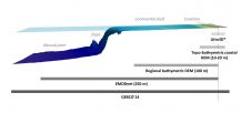
SHOM contributes routinely to the preparedness against coastal risks along French coastlines. For this purpose, regional to coastal digital elevation models are built for implementation in forecast systems against rapid...

Hydrographic mapping is all about collecting and processing data that leads to products such as nautical charts and other products contributing to safe navigation, a better environment and secure constructions...
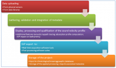
Hydrographic and geosciences surveys, using acoustic devices, need to use accurate water sound velocity profiles. Because the acoustic path depends on the sound velocity profile (SVP), the use of the...
The Fourth International Workshop on the Advances in the Use of Historical Marine Climate Data (MARCDAT-IV) will be held at the National Oceanography Centre, Southampton, UK between the 18th and 22nd July...
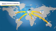
The Port of Rotterdam is Europe’s largest port and is one of the world’s key logistic hubs. Hydrographic data is critical to the Harbour master’s department for the operation of the Port of Rotterdam, to support the nautical accessibility of the deep-sea vessels by electronic nautical chart. The introduction of PortMaps enables the Port of Rotterdam to produce a wide variety of information products, including ENCs, from the Port’s survey data, in less than 48 hours. With over 500 line connections to and from more than 1,000 ports around the globe, the Port of Rotterdam in The Netherlands is the cornerstone of international freight transport. It is the...
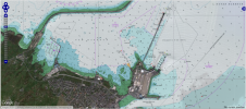
OceanWise, UK, has developed a set of specialist tools and methodologies to identify specific content from raster charts. By removing all content to the landward side of the coastline, OceanWise...

On the first day of Intergeo, RIEGL, Austria, showcased its latest development in UAS-based laser scanning: the RIEGL BathyCopter. This is a small-UAV-based surveying system capable of measuring through the...

The key objective of the NOAA Chart Adequacy Workshop was to demonstrate techniques to evaluate the suitability of nautical chart products using chart quality information and publicly-available information. The three-day...

For some years now EMODnet has been creating access to marine data sources. The long-term aim of EMODnet is to unlock the wealth of marine observations and data in Europe...
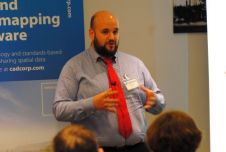
The ‘Blue Growth’ conference held in London in May 2015 and hosted by British software developer Cadcorp, was an opportunity for marine and maritime professionals to discuss some of the...
This site uses cookies. By continuing to use this website, you agree to our Cookies Policy. Agree