Laser-Scan Support for UKHO
Laser-Scan has signed a contract with the United Kingdom Hydrographic Office (UKHO), Ministry of Defence, for the support and maintenance of key operational production systems. The contract provides the UKHO...
Laser-Scan has signed a contract with the United Kingdom Hydrographic Office (UKHO), Ministry of Defence, for the support and maintenance of key operational production systems. The contract provides the UKHO...
In the framework of the EU-financed project EUROSEISMIC a central metadatabase for geophysical data derived from marine seismic surveys for the European Seas has been generated and developed. EUROSEISMIC established...
GEBCO uses deepwater survey data to produce bathymetry maps and grids. Published maps appear complete but are in fact based on very little data. Only a portion of the deep...
Canadian Hydrographic Service (CHS) recognises the need to improve its processes for data management and product creation to meet the high standards expected by the hydrographic community. From a task...
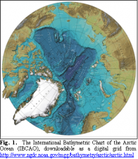
Bathymetric mapping remains incomplete in the Arctic and Southern Oceans. Some proposed International Polar Year activities could help improve the situation by collecting new soundings during vessel transits to and...
The Hydrographic Office (HO) is an important part of the National Geo-Spatial Data Infrastructure and, of course, the International Hydrographic Organization (IHO) has an important role to play in co-ordinating...
How to tackle problems traditionally associated with the management of multibeam data? A management tool has been developed which offers concrete operative solutions by eliminating lengthy manual editing stages and...
Acoustic seabed classification is rapidly gaining acceptance as a useful tool amongst the world's ocean community. Commercial classification products can measure acoustic diversity in the surficial seafloor zone and produce...
As more people adopt RTK GPS technology for measuring water levels, the issue of ellipsoid-geoid separation is increasingly being discussed. This article outlines various projects undertaken to calibrate this separation,...
The Electronic Chart situation has developed in an unexpected way. When the first standards for chart systems were being written, the concentration was on those installations which would become the...
This site uses cookies. By continuing to use this website, you agree to our Cookies Policy. Agree