Collating European Marine Data
The European Commission has concluded service contracts for creating pilot components of the European Marine Observation and Data Network (EMODnet). The overall objective is to create pilots to migrate fragmented...
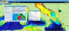
The European Commission has concluded service contracts for creating pilot components of the European Marine Observation and Data Network (EMODnet). The overall objective is to create pilots to migrate fragmented...
The Open Geospatial Consortium (OGC) Technical Committee's PUCK Standards Working Group was chartered to process the existing MBARI PUCK protocol as a candidate OGC standard compatible with the OGC Sensor...
With effect from 1 April 2011, a coastal monitoring programme is in place for the entire English coastline via a national network of coastal monitoring programmes. In addition to the...

This is a report on the first IHO sponsored Database Design and Management Training Course delivered to the East Asian Hydrographic Commission. The hydrographic community is tackling some of the...

During Ocean Business, CARIS officially launched and demoed the new version of Bathy DataBase 3.1 which as a new feature supports Oracle 11g. Delegates interested to see the new development...
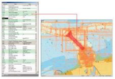
The Flemish Hydrography, part of the Flemish government in Belgium, is currently setting up and integrating a Marine Spatial Data Infrastructure (MSDI) for the Belgian coast, the canal Ghent-Terneuzen and...
The Geoportal Extension is to become a Free and Open Source solution from Esri. Despite code documentation and samples as included on the Geoportal Resource Center, implementers of the Geoportal...
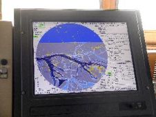
e-Navigation is a concept being developed under the auspices of the UN’s International Maritime Organization (IMO) to bring about increased safety and security in commercial shipping through better organisation of...

The coastal zone is immensely important for humankind, marine and coastal spatial planning is a vital tool for planning and preserving the world’s coasts. Ron Furness, is a nautical cartographer,...
Esri expands the power of geoportals with the release of the ArcGIS Server 10 Geoportal extension. The extension allows organisations to quickly set up websites, called geoportals that help them...
This site uses cookies. By continuing to use this website, you agree to our Cookies Policy. Agree