The evolution of Dutch hydrography
Given the Netherlands’ geographical location, it is unsurprising to find it has a long tradition of hydrography. The lowland, often below sea level, forms a delta where major rivers from...

Given the Netherlands’ geographical location, it is unsurprising to find it has a long tradition of hydrography. The lowland, often below sea level, forms a delta where major rivers from...

Fujitsu has presented a pioneering technology that harnesses Lidar and AI to capture high-resolution 3D data of organisms, coral reefs and man-made structures such as offshore wind turbines using autonomous...

A consortium of USV and hydroacoustic tech firms, including ACUA Ocean, GeoAcoustics and Unmanned Survey Solutions (USS), has secured funding from the British Department for Environment, Food and Rural Affairs...

Subsea specialist Sulmara has played a pivotal role in advancing Bayou Bend CCS LLC’s efforts through the utilization of technology. During a recent high-resolution geophysical survey for the Bayou Bend carbon...
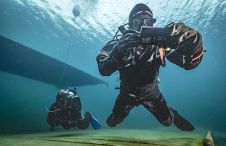
The innovative system facilitates map-based navigation for divers on a mission, offering the flexibility of seamless two-way communication between divers and the dive supervision team, as well as pre-mission and...

Ocean surveying and inspection specialist Argeo Subsea, CSI Nordics and Kongsberg Discovery have formalized a three-party Certificate of Delivery and Acceptance for an advanced HUGIN Superior AUV. This milestone agreement,...

Between January 2023 and February 2024, TDI-Brooks, a specialized company in geotechnical and offshore survey projects, conducted an extensive site investigation programme across two offshore wind blocks in state and...

Geospatial cloud specialist north.io has announced it aims to revolutionize the modelling, collection and processing of ocean data using NVIDIA technologies. According to Jann Wendt, CEO, north.io, the synergy between...

By harnessing capabilities of advanced satellite technology and ever-evolving data analysis, satellite-based mapping (including satellite-derived bathymetry, SDB) offers an efficient, extensible and cost-effective method for mapping water properties, underwater topography...

Kongsberg Discovery commemorates 30 years of inertial navigation excellence with the launch of Seapath 385. Unveiled at Oceanology International in London, this innovative system integrates new hardware and advanced navigation...
This site uses cookies. By continuing to use this website, you agree to our Cookies Policy. Agree