Seazone Solutions Ltd
The acquisition of hydrographic data has successfully supported the production of paper and electronic navigational charts for many years. Hydrographic offices worldwide are rightly committed to providing products in which...
The acquisition of hydrographic data has successfully supported the production of paper and electronic navigational charts for many years. Hydrographic offices worldwide are rightly committed to providing products in which...
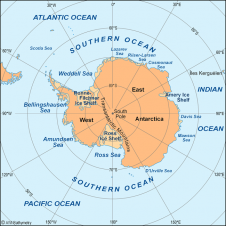
The Scientific Committee on Antarctic Research (SCAR) expert group for the compilation of the new International Bathymetric Chart of the Southern Ocean (IBCSO) proposes to build a consistent bathymetric database...
The US Navy has a strong tradition in hydrography and has restated its commitment to this field by naming the Commander of the Naval Meteorology and Oceanography Command as the...
Since GPS found its way into positioning, differential processing has beentheway to high precision. Technological advances and large-scale international collaboration have now made it possible to get sub-decimetre accuracy (95%,...
Regional Patterns and Local Variations of Sediment Distribution in the Hudson River Estuary Nitsche, F.O., Ryan, W.B.F., Carbotte, S.M., Bell, R.E., Slagle, A., Bertinado, C., Flood, R., Kenna, T. and...
Ships and their pilots have difficulties in entering a harbour during periods of relatively high flow velocities. We developed a system that gives real time depth average flow velocity and...
News East Australia Region The headquarters of the Australian Maritime Safety Authority in Canberra was the venue for an East Australia Region General Meeting on Wednesday 11th August 2004. Our...
News The Australasian Hydrographic Society congratulates the Australian Hydrographic Service on achieving a milestone on 26th August 2005, when it was certified as a ‘Quality Endorsed Company’ under ISO 9001:2000....
Sophisticated wave models like SWAN (Simulating Waves Nearshore) are used to calculate extreme wave and water heights that may occur in the North Sea. Accuracy of these models and predictions...
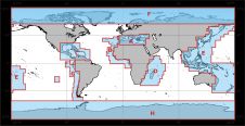
Since the 1970s, the International Bathymetric Charts (IBCs) of the Intergovernmental Oceanographic Commission have offered a framework for compiling soundings with a view to producing detailed maps of sea floor...
This site uses cookies. By continuing to use this website, you agree to our Cookies Policy. Agree