Marinestar global satellite positioning
Fugro Marinestar measures GNSS satellite orbit and clock corrections for GPS, GLONASS, Galileo and BeiDou. These corrections are sent over six geostationary L-band satellites and over internet and can be...
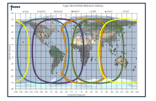
Fugro Marinestar measures GNSS satellite orbit and clock corrections for GPS, GLONASS, Galileo and BeiDou. These corrections are sent over six geostationary L-band satellites and over internet and can be...
Combining the DriX uncrewed surface vehicle (USV) and the FlipiX remotely operated towed vehicle (ROTV), Exail has developed a unique solution enabling fully autonomous and remotely operated surveys. Combining the DriX uncrewed surface vehicle (USV) and the FlipiX remotely operated towed vehicle (ROTV), Exail has developed a unique solution enabling fully autonomous and remotely operated surveys. Accurate surveys...

SIDUS Solutions, LLC, headquartered in San Diego, CA, is a manufacturer and an integrated systems provider of robust video surveillance systems. We provide services and equipment for subsea, heavy commercial,...
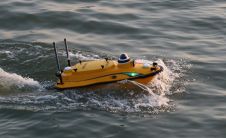
CHC Navigation (CHCNAV), a leading manufacturer of uncrewed surface vehicle (USV) technology, has introduced the Apache 3 Pro – an advanced compact hydrographic drone engineered for autonomous bathymetric surveys in...
Within the last twenty years Global Positioning System (GPS) receivers have revolutionised navigation. Integrated devices are capable of providing time, position, height, direction, heave and attitude to accuracies of a...
By Camille Béchaz, ACSA and François Boucquaert, Fugro-Topnav, France Fugro evaluated the accuracy of the GPS Intelligent Buoy (GIB-Lite) system for its possible use in shallow-water offshore underwater positioning applications....
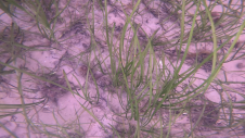
Seagrass meadows play an invaluable role as critical ecosystems that contribute significantly to marine biodiversity, carbon sequestration and coastal protection. In recent years, the importance of these underwater habitats has...
Whenever new objects have to be created, be it on or below the land and water, construction plays a role. The construction process often starts with surveying, either [marine surveying]...
Sercel (France) has launched GeoTag, an acoustic positioning solution for seabed seismic acquisition. GeoTag can be used to accurately position all types of ocean bottom cable (obc), ocean bottom node...
This site uses cookies. By continuing to use this website, you agree to our Cookies Policy. Agree