Real-time Marine Monitoring Systems
The seas are being monitored, from satellite observations of the ocean surface to the growing number of in-situ measurement networks. The amount of information being generated is huge and should...
The seas are being monitored, from satellite observations of the ocean surface to the growing number of in-situ measurement networks. The amount of information being generated is huge and should...
The seas are being monitored, from satellite observations of the ocean surface to the growing number of in-situ measurement networks. The amount of information being generated is huge and should...
The seas are being monitored, from satellite observations of the ocean surface to the growing number of in-situ measurement networks. The amount of information being generated is huge and should...
The NOAA National Ocean Service, Center for Operational Oceanographic Products and Services (CO-OPS) has installed a real-time wave/current measurement system in the Chesapeake Bay (MD, USA) using a bottom-mounted RD...

IHO standard S-44 is often used (or misused) to specify the quality of a hydrographic survey. While it is a useful tool, it is easy to misinterpret. One ‘misuse’ is...
The Danish Geodata Agency, alongside several collaborators, is currently conducting trials on the latest iteration of navigational charts in the Baltic Sea region. This initiative forms part of an EU-funded...
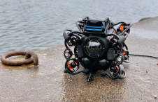
HydroSurv, a prominent provider of electric and hybrid uncrewed surface vessels (USVs), has successfully secured Innovate UK funding to advance the commercialization of an end-to-end seagrass monitoring solution. This endeavour...
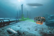
The Mexico port authorities have enhanced their port security capabilities with the recent acquisition of nine advanced Oceanbotics SRV-8 professional underwater drones (ROVs). This strategic move aims to elevate their surveillance...
The esteemed Finnish Geospatial Research Institute (FGI) is set to utilize advanced Lidar systems developed by the Fraunhofer Institute for Physical Measurement Techniques IPM for future maritime surface surveys. Anticipating...
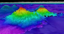
The crew of Schmidt Ocean Institute’s research vessel Falkor (too) recently discovered four underwater mountains – the tallest of which exceeds 2.4km in height – during a January transit from...
This site uses cookies. By continuing to use this website, you agree to our Cookies Policy. Agree