The evolution of Dutch hydrography
Given the Netherlands’ geographical location, it is unsurprising to find it has a long tradition of hydrography. The lowland, often below sea level, forms a delta where major rivers from...

Given the Netherlands’ geographical location, it is unsurprising to find it has a long tradition of hydrography. The lowland, often below sea level, forms a delta where major rivers from...

An international expedition to the Salas y Gómez Ridge has uncovered 160 species, potentially including 50 new to science. Led by Dr Erin E. Easton and Dr Javier Sellanes, the...

Subsea specialist Sulmara has played a pivotal role in advancing Bayou Bend CCS LLC’s efforts through the utilization of technology. During a recent high-resolution geophysical survey for the Bayou Bend carbon...

SEA-KIT International, a leading designer and builder of uncrewed surface vessels (USVs), achieved a significant milestone in 2021 when it received the first-ever Unmanned Marine Systems (UMS) certificate from Lloyd’s...
Autonomous vessel operations company Massterly has opened its Remote Operations Centre (ROC) in Horten, Norway. This significant step marks a crucial transition from the testing phase to fully-fledged operational capabilities...

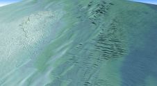
By harnessing capabilities of advanced satellite technology and ever-evolving data analysis, satellite-based mapping (including satellite-derived bathymetry, SDB) offers an efficient, extensible and cost-effective method for mapping water properties, underwater topography...
The practice of identifying and monitoring an area's physical features by measuring its reflected and emitted radiation from a distance is known as remote sensing (typically from satellite or aircraft). Researchers can "sense" facts about the Earth by using special cameras to acquire remotely sensed photos. Remote sensing is a fascinating field that revolves around the acquisition of Earth-related information without direct physical contact. It typically yields either point cloud data or imagery, both of which...
The latest innovation from Exail, a prominent provider of maritime autonomy solutions, is the DriX O-16, a transoceanic uncrewed surface vessel (USV). With an impressive autonomy range of 2,500 nautical...

In an era of great power competition, unmanned maritime systems (UMSs) have begun to take centre stage and are now on an accelerated development path for reasons that are clear....
Teledyne Geospatial has announced that Tetra Tech, a leading provider of high-end consulting and engineering services, recently acquired a Teledyne Optech CZMIL SuperNova Topobathymetric Lidar system. Tetra Tech has successfully...
This site uses cookies. By continuing to use this website, you agree to our Cookies Policy. Agree