Remote hydrography and regulation: mission impossible?
The development of unmanned and autonomous surface vehicles in recent years has triggered a new era in civilian and military maritime operations. One of the applications that is likely to...

The development of unmanned and autonomous surface vehicles in recent years has triggered a new era in civilian and military maritime operations. One of the applications that is likely to...
The ocean plays a crucial role in mitigating climate change, yet we lack detailed information on over 95% of the seafloor. This article explores planblue’s solution to accelerate time-to-data and...
DWTEK, the Taiwanese underwater tech developer, achieved a significant milestone last month by supporting local offshore wind farm surveying with its working-class ROV Monew on the west side of the...
The Norwegian Hydrographic Service (NHS) has awarded Fugro a new hydrographic survey contract for the 2023 MAREANO seabed mapping programme. This is the latest in a series of contracts that...
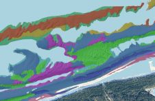
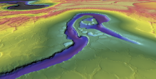
This article presents a novel methodological approach to understand and assess the suitability of airborne Lidar bathymetry for the automatic classification and mapping of the seabed. This solution allows recording of...
Combining the DriX uncrewed surface vehicle (USV) and the FlipiX remotely operated towed vehicle (ROTV), Exail has developed a unique solution enabling fully autonomous and remotely operated surveys. Combining the DriX uncrewed surface vehicle (USV) and the FlipiX remotely operated towed vehicle (ROTV), Exail has developed a unique solution enabling fully autonomous and remotely operated surveys. Accurate surveys...
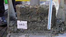
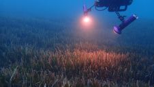
Activities such as sand extraction, cable trenching and pipeline construction regularly churn up the top layer of the North Sea seabed. However, this top half metre is an important habitat for all...
The Nippon Foundation-GEBCO Seabed 2030 project and Saildrone, a leading provider of unmanned surface vehicles (USVs), have signed a memorandum of understanding (MOU) to collaborate on advancing ocean mapping technology...

Seabed 2030 is rapidly approaching its ultimate objective of mapping the entire seabed within seven years. To achieve this goal, the project is actively seeking donations of both public and...
This site uses cookies. By continuing to use this website, you agree to our Cookies Policy. Agree