Diving Companies Add Side Scan
More commercial diving companies are adding side-scan surveys to the mix of services they offer. Some are purchasing sonars to provide them with the capability of finding lost objects, to...
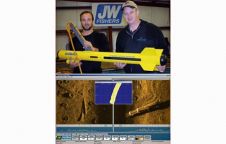
More commercial diving companies are adding side-scan surveys to the mix of services they offer. Some are purchasing sonars to provide them with the capability of finding lost objects, to...
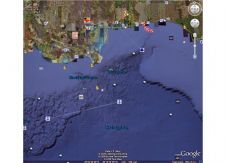
Last week, Google launched Google Earth 5.0. This version includes the long-expected addition of oceanic images and bathymetry. People will be able to see the underwater topography; search for particular...
As a first-time host, CodaOctopus Products is announcing the 44th meeting of the Marine Measurement Forum, taking place at the Scotsman Hotel in Edinburgh (Scotland) on 21st May 2009. ...
Many universities are now adding ROVs to their marine science programs. These remote-controlled camera systems can assist in a multitude of operations including underwater archaeology, monitoring the health of benthic...

Modern Hydrography needs to be embedded in the much wider context of geographic information gathering and dissemination. This message will be broadcasted during Hydro2010 in Rostock, Germany in November this...
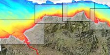
AZTI-Tecnalia, Spain, has presented the cartography for the sea beds off the coast at the Basque cities of Donostia-San Sebastián and Bilbao. The high-precision material is aimed at use for...
The Director-General of UNESCO, Irina Bokova, expressed concern about negotiations to sell a large number of artefacts salvaged from the wreck of a 10th century ship lying off the coast...
The Dutch East India Company, the Verenigde Oostindische Compagnie (VOC), was founded in 1602. In so doing it became the first multinational corporation in the world, and only the third...
The "AMAP2 - Characterising the Potential for Wrecks" project (AMAP2), commissioned in October 2009, is a collaborative project between SeaZone and the University of Southampton (UoS) which seeks to improve...
Nearly sixty leading representatives from the UK Hydrographic Office, the Maritime & Coastguard Agency, the Port of London Authority and major survey industry organisations gathered for a festive World Hydrography...
This site uses cookies. By continuing to use this website, you agree to our Cookies Policy. Agree