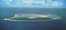
Marine Spatial Planning in North Sea Region
Ocean businesses gathered online to discuss the challenges and perspectives of marine spatial planning (MSP) in the North Sea region at a World Ocean Council (WOC) and Scottish Association for...
Ocean businesses gathered online to discuss the challenges and perspectives of marine spatial planning (MSP) in the North Sea region at a World Ocean Council (WOC) and Scottish Association for...
The Memorial University Fisheries and Marine Institute, USA, will inaugurate the new Master of Marine Studies in Marine Spatial Planning (MSP) and Management, the first graduate programme of its kind...
Future implementation of the European Union (EU) Directive on Maritime Spatial Planning (MSP) in the Baltic Sea region as well as exchange of MSP data were among the main topics...
England’s first ever plans for the future of our seas have been published on 2 April 2014. The marine plans – which provide guidance for sustainable development in English waters...

In May 2013 the HELCOM Secretariat received an unexpected email from Vietnam, asking for permission to translate the book Planning the Bothnian Sea into Vietnamese. Five months later, in October...
At the Eye on Earth Summit in Abu Dhabi last week, the Geographic Information System (GIS) software company Esri committed to building a database for the Cook Islands Marine Park...
Lidar, short for Light Detection and Ranging surveying, represents a sophisticated measuring system leveraging the power of light. Widely recognized for its versatility, Lidar is extensively applied in diverse fields...
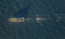
Fugro has secured the geophysical survey contract for the Dutch Doordewind offshore wind farm zone development. Fugro’s selection was driven by its pioneering 2D ultra-ultra-high resolution (UUHR) surveys, delivering unparalleled...
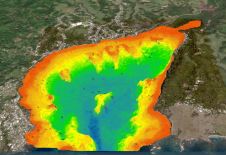
A deep understanding of seabed topography and coastal features is crucial for developing predictive models to address challenges such as coastal inundation and rising sea levels. Communities worldwide rely on...
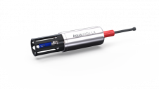
The AquapHOx underwater long-term loggers enable accurate and higly resolved total pH measurements, long-term O2 monitoring and trace O2 detection. They are available as single analyte shallow water and flexible deep-sea multi-analyte loggers. The cost-effective and easy-to-operate deep sea logger allows to measure O2 or total scale pH with the same compact instrument succesively. Simply exchange the sensor head, choose between different analytes and sensor formats and deploy down to 4000m water depth. For advanced underwater applications, PyroScience recently launched the unique all-in-one AquapHOx platform for monitoring critical parameters and their dynamics underwater; in open ocean, the deep sea, coastal ecosystems, rivers, lakes...
This site uses cookies. By continuing to use this website, you agree to our Cookies Policy. Agree