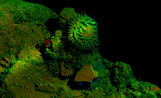
School of Surveying & Spatial Information System
We will cover the installation of vessel and ROV survey equipment and explain the importance of offsets, calibrations and installation checks. We will discuss the relevance of the installation positions...
Lowestoft-based multipurpose vessel MV FlatHolm finished off a busy year in 2016 with a successful charter to James Fisher Marine Services, undertaking a variety of service activities in connection with...
The University of Plymouth is working with a pioneering technology business to develop a revolutionary means of gathering data about the marine environment. The company HydroSurv is developing a range...
A recent article provides an overview of satellite-derived bathymetry methods and how data can be integrated into survey campaigns, and showcases three use cases. Bathymetric data in shallow-water zones is...
A Korean vessel, currently surveying the East Sea, is reported to have made its way to the country's easternmost islets of Dokdo. According to Kyodo News Agency at 6:40 a.m....
Hydrological monitoring and mapping will not be allowed in China and hydrological organizations are now expected to strengthen their monitoring of changes in water flow and quality that could potentially...
The Government of Guyana, through an agreement with the United Kingdom, has benefited from a Commonwealth Maritime Economics Programme in Hydrographic Surveying. Guyana was able to access funds for more...
Hydrographic surveying is highly specific and requires a suite of advanced acquisition and positioning sensors attached to a mobile survey platform as well as sophisticated software to allow the correct...
This site uses cookies. By continuing to use this website, you agree to our Cookies Policy. Agree