UAV show China 2017 & China Unmanned Systems Expo 2017
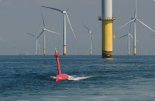
With hundreds of new offshore wind projects in development around the world and annual growth of almost 30%, offshore wind is a rapidly maturing renewable energy technology that offers great potential. Bolstered by national policies and decreasing technological costs, the global offshore wind market is set to expand strongly in the coming decades, whether in Europe, Asia or the US, and is forecast to “increase 15-fold to 2040, becoming a $1 trillion industry over the next two decades. With hundreds of new offshore wind projects in development around the world and annual growth of almost 30%, offshore wind is a rapidly maturing renewable energy technology that offers great...
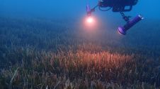
The ocean plays a crucial role in mitigating climate change, yet we lack detailed information on over 95% of the seafloor. This article explores planblue’s solution to accelerate time-to-data and...

Fugro has utilized its cutting-edge hydrographic technology in Australia to locate the final resting place of the Montevideo Maru, which sank in 1942 with more than 1,200 people on board....
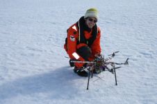
Engineers on board the Alfred Wegener Institute’s research icebreaker Polarstern have programmed an unmanned autonomous vehicle (UAV), allowing it to navigate despite the deviations produced by the Earth’s magnetic field...
Fugro has extended its integrated survey services to help improve efficiency in coastal management and enable more informed decision making. A new agreement with global specialist EOMAP enables the creation...
Bluefin Robotics, USA, has successfully integrated the Solstice - search and classify sidescan sonar with integrated swath bathymetry sonar - into the Bluefin-12 AUV. The company collaborated with Sonardyne International,...
The United Kingdom Hydrographic Office (UKHO) is providing satellite images to help with the cleanup operation following typhoon Haiyan. A request came from the Royal Navy warship, HMS Daring, for...
The French Hydrographic Office (SHOM) uses remotely sensed visible imagery for the cartography of atolls and reefs. It is considered as an efficient and relatively inexpensive method to collect information...
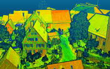
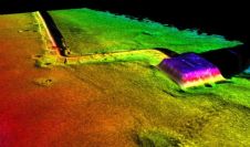
Lidar mapping based on unmanned aerial vehicles (UAVs or ‘drones’) can generally be thought of as a close-range version of manned airborne laser scanning. In brief, lower mobilization costs and...
This site uses cookies. By continuing to use this website, you agree to our Cookies Policy. Agree