
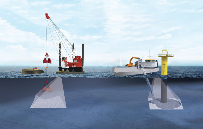
An estimated 95% of the oceans remains unexplored today, implying a huge market opportunity for innovative marine survey solutions. While the boom in offshore renewables projects will certainly continue, the blue economy is bringing new opportunities for hydrographers. Common across all applications is use of state-of-the-art sonar equipment that is operable from different platforms.
Sonar systems have long served as the “eyes” of underwater exploration. However, challenging environments – rough, unpredictable seas and the need to work under or near structures such as wind turbine monopiles – have remained an impediment to survey operations. A primary innovation facilitating today’s offshore renewables market is therefore the integration of active motion stabilization into small form factor, low power draw, tightly integrated multibeam echosounder systems. These new developments give hydrographers powerful tools, eliminating the need to compromise between swath width, speed of data collection and data density. The latest technologies bring challenges too, as both the client-operator and contractor need to understand the capabilities to maximize their benefits.
Increased data quality and survey efficiency
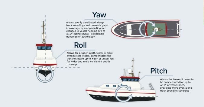
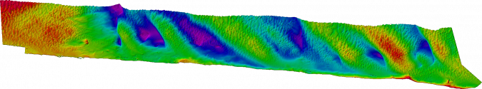
NORBIT Subsea integrates active motion stabilization into a family of compact, high-resolution, wide swath multibeam echosounder systems such as the WINGHEAD i80S and the just launched iWBMSh Stabilized system. Active stabilization is different from motion correction for georeferencing purposes in that the beam is actively steered to compensate for vessel roll, pitch and yaw.

Fully Active Stabilization by NORBIT Subsea
Steerable transmission functionality for superior feature identification
Steerable transmission functionality (STX), built into the NORBIT WINGHEAD “S” series and WBMS STX sonars, is another key advancement aiding offshore applications. STX scanning lets the operator direct the transmit beam by ±10° in a scanning pattern. The result is a revolutionary new data deliverable utilizing multi-look capabilities to reduce shadows and improve feature characterization. This aids inspection surveys by giving a more complete picture of the survey area or target. Additionally, it can be used to capture extra detail on complex structures, such as offshore turbine jackets and transformer platforms, during a single pass or measurement.
Other applications of STX scanning include obstacle avoidance, dredge monitoring and cable lay operations. The system can be mounted in any orientation to change the scanning pattern. For example, rotating the sonar to face athwart-ships with a slight upward tilt allows the sonar to scan a ±10° sector ahead of the vessel, providing high-accuracy, forward-looking bathymetric data.
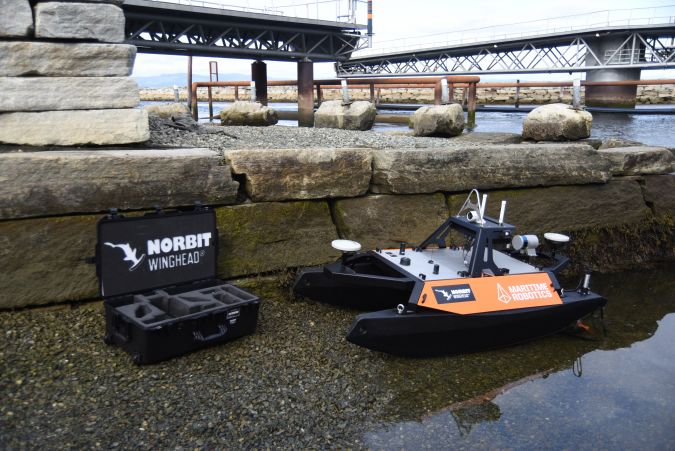
The STX system can be mounted with a rotator to provide 360° real-time monitoring of the seabed and water column from a static platform. This iSTX360 solution, together with its intuitive software, simplifies the survey experience and provides a concurrent work platform for both vessel operators and hydrographers. It is suited for any uncrewed surface vessel (USV) or other surface vessel, including barges, or for deployment from static locations such as breakwaters or quay walls.
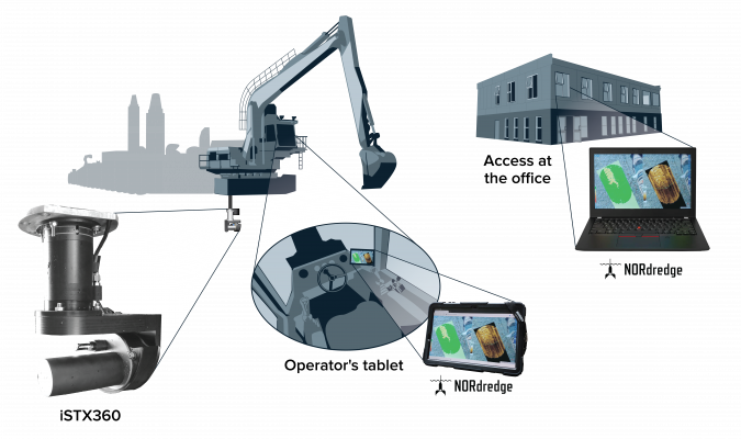
The iSTX360 offers key efficiency benefits that include quick mobilization, fewer personnel needed on-site, the ability to acquire pre-/post-datasets during operations, real-time placement and in-fill monitoring without waiting for a survey vessel, and the ability to identify and avoid hazards in real time. This enables operations to be focused where needed, minimizing equipment moves and expensive rework.
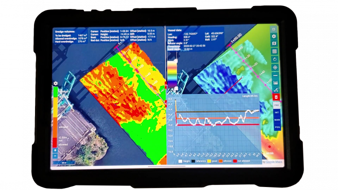
The NORdredge software environment (Figure 4) provides simultaneous, multi-user access for expedited communication across the project team. This allows remote change detection and analysis, quality control and instant remote upload of design templates/adjustments to plan for real-time progress reporting and optimized resource management.
Bringing gains in processing power and cloud computing to the hydrographic space
“Collect once, use many times” approaches to data gathering are evident across hydrography. This implies harvesting maximum data from field operations and making rich datasets available for multiple users and multiple uses, at different locations around the globe.
NORdredge is a web-oriented utility that directly interfaces to the NORBIT iSTX360 multibeam sonar system. It is based on the NORBIT Open Hydrography Platform (OHP) and represents a continued development of the company’s bathymetry data acquisition software, DCT. Because the architecture of NORdredge facilitates remote access, a remotely located hydrographer or engineer can perform advanced tasks – from survey design to real-time data acquisition and quality assurance – while the operator conducts the survey using a handheld device such as a mobile phone or tablet.
Concurrently, other personnel can monitor survey operations from any location around the world, which may even involve the remote deployment of USV platforms for further investigative or other tasks.
The process for the hydrographer is as follows:
- Prepare the design template according to project requirements.
- Identify potentially hazardous locations and communicate these to operator in real time.
- While operator conducts survey, independently access the data and check coverage, plots and profiles without disturbing the operator.
Simplifying bathymetry survey operations with DCT
NORBIT’s Integrated Data Acquisition Software, DCT, similarly simplifies standard bathymetry survey operations. The bathymetry grid is displayed in a web browser, providing a quick indication of coverage and data quality while running the survey. DCT is ideal for inexperienced multibeam sonar operators, small vessels and single-person operations, as well as USVs with low-bandwidth radio connectivity to the operator. It can be operated from a simple touch screen on a navigation plotter, tablet, smartphone or PC. The four available real-time displays (depth, sounding density, backscatter and standard deviation) can run concurrently on one or several clients, so while the skipper views the depth display, a surveyor or remote QA assistant can view standard deviation and sounding density.

DCT offers a simple, reliable data collection method with predictable and known data outputs. All data is collected in NORBIT wbm files and in the popular s7k file format. Collecting everything with respect to the ellipsoid can allow larger organizations to send less experienced personnel into the field without the worry that geodetic settings will be incorrect.
NORBIT Subsea is part of the Oceans Division of NORBIT ASA. Its solutions are based on the latest in analogue and digital signal processing and its products provide wide-coverage monitoring combined with high sensitivity and accuracy.
References
World Dredging, Mining & Construction, Vol. 53, Nos. 11/12-3/21 (WorldDREDGING.com)
NORBIT Data Sheets, April 2023