Chart Updating
By Roosmarijn Haring Safety of navigation is essential for the protection of lives and the environment. This is the basic premise of the United Nations (1974) proclamation entitled SOLAS...
By Roosmarijn Haring Safety of navigation is essential for the protection of lives and the environment. This is the basic premise of the United Nations (1974) proclamation entitled SOLAS...
The Norwegian Hydrographic Service (NHS) is conducting a prototype development project for a print on demand service, intending to facilitate chart users ordering updated nautical charts from the Hydrographic Service....

The Republic of Cabo Verde, an archipelago located 500km off the west coast of Africa in the Atlantic Ocean, has taken a stride towards improving its hydrographic capacity by becoming...
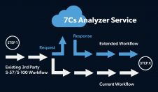
SevenCs has announced the launch of its 7Cs Analyzer Service Application Programming Interface (API). Chart producers and hydrographic offices of all sizes can use this new API to activate the...

Geomares Publishing have released the third and totally revised edition of the book 'The Electronic Chart: Functions, Potential and Limitations' by the highly respected authors Horst Hecht, Bernhard Berking, Mathias...

The United Kingdom Hydrographic Office (UKHO) Admiralty Leisure has launched the latest in its series of ever-popular Tough Charts in the form of a brand new Tough Chart for Plymouth...
IIC Technologies has been selected by the UK Hydrographic Office to provide Hydrographic Database (HDB) services. IIC will help populate the UKHO's hydrographic database using secure, remote connection technology. ...
Caris is presenting Ping-to-Chart Workshops to be hosted at Stockholm University (Sweden) from 12th to16th October 2009 as well as at the University of Southampton (United Kingdom) from 18th to...
UTEC Survey is now well into the first phase of its hydrographic survey of offshore Dubai. Work began at the beginning of October 2008 and the processing and hand-over of...
The two most significant developments in navigation for many decades have been the introduction of global satellite navigation systems, such as GPS, and the electronic chart. In the case of...
This site uses cookies. By continuing to use this website, you agree to our Cookies Policy. Agree