Coastal Zone and Bathymetric Lidar Conference Session
The first European Lidar Mapping Forum event is being held in The Hague, in the Netherlands from 30th November to 1st December 2010 and will have two conference sessions devoted...

The first European Lidar Mapping Forum event is being held in The Hague, in the Netherlands from 30th November to 1st December 2010 and will have two conference sessions devoted...
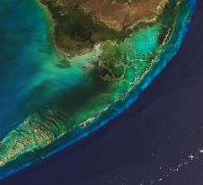
The Florida Department of Environmental Protection has commissioned Woolpert to acquire bathymetric survey data using Lidar technologies to support the Florida Seafloor Mapping Initiative (FSMI) and its mission to produce...

In the quest to unravel the mysteries beneath our planet’s water bodies, topobathymetric technologies emerge as a beacon of innovation. Among them, Lidar (light detection and ranging) and sonar sensors...

Narcisa Pricope is an associate vice president for research in the Office of Research and Economic Development at Mississippi State University and a professor in the Department of Geosciences. Prior...

Oceanology International 2024 (Oi24) is set to captivate attendees with a showcase of pioneering companies and innovative technologies, all poised to command attention at London's ExCeL. From advanced autonomous vehicles...
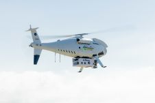
Fugro recently introduced its next-generation coastal mapping system, the Rapid Airborne Multibeam Mapping System (RAMMS 2.0), at the Hydro 2023 conference in Genoa, Italy. RAMMS 2.0, the world’s only airborne...

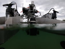
RIEGL has announced the launch of two innovative topobathymetric scanners. These advancements mark a shift towards enhanced efficiency and precision in data collection across land and water interfaces. The RIEGL...

IIT Madras has established a Centre of Excellence (CoE) dedicated to advancing indigenous maritime technology and expertise. The team of researchers leading this initiative has been actively engaged in notable...
HydroSurv, a prominent provider of electric and hybrid uncrewed surface vessels (USVs), has successfully secured Innovate UK funding to advance the commercialization of an end-to-end seagrass monitoring solution. This endeavour...
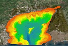
A deep understanding of seabed topography and coastal features is crucial for developing predictive models to address challenges such as coastal inundation and rising sea levels. Communities worldwide rely on...
This site uses cookies. By continuing to use this website, you agree to our Cookies Policy. Agree