China Expands Nautical Chart Coverage
With the publication of a new batch of paper and electronic nautical charts for foreign sea areas in late June 2014, the nautical charts developed by the Navy Publishing House...
With the publication of a new batch of paper and electronic nautical charts for foreign sea areas in late June 2014, the nautical charts developed by the Navy Publishing House...
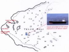
When ships run aground unexpectedly, the initial presumption is that the vessel has struck an ‘uncharted’ feature. However, in practice this is rarely so. A number of chart-related casualties demonstrate...
When ships run aground unexpectedly the initial presumption is that the vessel has struck an ‘uncharted’ feature. In practice this is rarely so. This article reviews a number of chart-related...
NOAA Office of Coast Survey has released a new nautical chart for the Arctic, which will help mariners navigate the Bering Strait. Chart 16190 (Bering Strait North) incorporates precise depth...
Nautical charts are expensive, and in many countries data are not always up to date. OpenSeaMap is an alternative solution which is free for anybody to use worldwide. Following the...

In the quest to unravel the mysteries beneath our planet’s water bodies, topobathymetric technologies emerge as a beacon of innovation. Among them, Lidar (light detection and ranging) and sonar sensors...
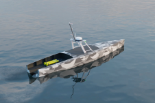
Autonomous vessel experts and artificial intelligence (AI) pioneers behind the first full-size unmanned research vessel to conduct scientific experiments while autonomously navigating the Atlantic Ocean have announced their plans to...
L-3 Nautronix has released Electronic Navigation Chart (ENC) Analyzer Software Version 2.8. The software, which is used to produce, manage and distribute electronic navigation charts and paper charts, advances the...
He started his career as a meteorologist, became head of the computer section of the ‘Deutsches Hydrographisches Institut’ (DHI) in 1970 and was responsible for IT affairs, which brought him...
Italy is the first nation officially to adopt ECS systems - other than ECDIS - as equivalent standard to paper charts. The approved ECS systems, as defined by issued standard,...
This site uses cookies. By continuing to use this website, you agree to our Cookies Policy. Agree