Raster Charts Entering GIS Era
OceanWise, UK, has developed a set of specialist tools and methodologies to identify specific content from raster charts. By removing all content to the landward side of the coastline, OceanWise...
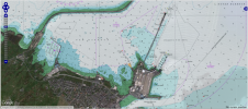
OceanWise, UK, has developed a set of specialist tools and methodologies to identify specific content from raster charts. By removing all content to the landward side of the coastline, OceanWise...

Utilising full-motion video (FMV) technology, CSA Ocean Sciences Inc. (CSA) marine biologists have successfully conducted an underwater biodiversity survey. FMV is defined as digital video with integrated geospatial information (real-time...

PD Ports is streamlining the way it shares hydrographic data by using GIS software from British software developer, Cadcorp, at Teesport. Handling around 40 million tons of cargo per annum,...

Ocean scientist, geographer, and geographic information system (GIS) author Dawn J. Wright will join Esri as its chief scientist on 3rd October 2011. She will help formulate and advance the...
Ocean Globe from ESRI Press examines bathymetry from its early history through today's use of geographic information systems (GIS) and other technologies to map the ocean floor. With contributions from...
ESRI is hosting the 2009 ESRI T3G Institute (Teachers Teaching Teachers GIS), from 14 to 19 June 2009, at its company headquarters in Redlands (CA, USA). Teachers of grades 5-12,...
Essays on Geography and GIS, the latest offering from the Best Practices series published by geographic information system (GIS) software developer ESRI, is a collection of essays written by many...
In days long gone by, it used to be said that electronics and the marine environment did not mix. Well, it is still true that electricity and water don’t mix...
Site investigation surveys involving hydrographic or geotechnical data acquisition often generate high volumes of data and require handling through specialist software packages. The combination of volume of data and variety...

Representatives from some of Britain's leading insurers were given an insight into the power of Ordnance Survey information at a special event focusing on flood risk. Directors, managers and specialist...
This site uses cookies. By continuing to use this website, you agree to our Cookies Policy. Agree