Web GIS Improves Lidar Collection Response Time
The remarkable capabilities of airborne Lidar continue to improve, with scanners now able to emit more than a million pulses every second. Although it has never been easier to acquire...
The remarkable capabilities of airborne Lidar continue to improve, with scanners now able to emit more than a million pulses every second. Although it has never been easier to acquire...
The Israeli Navy Hydrographic Branch (INHB) is transforming itself into a 21st-century organization. Moving away from traditional methods of generating hydrographic products, INHB has adopted geographic information system (GIS) technology....
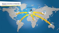
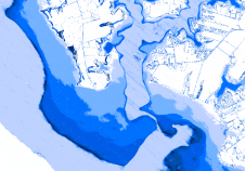
The Port of Rotterdam is Europe’s largest port and is one of the world’s key logistic hubs. Hydrographic data is critical to the Harbour master’s department for the operation of the Port of Rotterdam, to support the nautical accessibility of the deep-sea vessels by electronic nautical chart. The introduction of PortMaps enables the Port of Rotterdam to produce a wide variety of information products, including ENCs, from the Port’s survey data, in less than 48 hours. With over 500 line connections to and from more than 1,000 ports around the globe, the Port of Rotterdam in The Netherlands is the cornerstone of international freight transport. It is the...
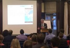
Independent marine data management, publishing and GIS specialist OceanWise held its Marine GIS Workshop in London, UK, on Tuesday 18 November 2014 at the School of Economic Science to great...

The Hydrographic Department, Royal Thai Navy (HDRTN) implemented an enterprise production system in early 2014. The enterprise geographic information system (GIS) will enhance the management and provision of spatial data...
The Puerto Rico GIS Professionals Association (AProSIG acronym in Spanish) is a not for profit corporation registered in the Commonwealth of Puerto Rico aiming to bring together individuals professionally engaged...
NOAA’s just-completed first-edition VDatum tool will allow users to combine and transform geospatial data from different sources onto a single vertical reference surface, removing the largest obstacle GIS users face...

SeaZone Group, UK, has increased its North Sea data coverage for use in GIS. This is a timely development for many of its customers in view of the increased renewable...
This site uses cookies. By continuing to use this website, you agree to our Cookies Policy. Agree