Sensing Earth
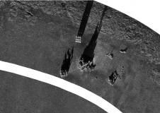
In soil and sediment studies, geophysical mapping is often used as a prerequisite to focus or guide traditional sampling and coring of the locations of interest. This way, synoptic and...
In soil and sediment studies, geophysical mapping is often used as a prerequisite to focus or guide traditional sampling and coring of the locations of interest. This way, synoptic and...
Australian company Fastwave has released the Go Remote photo and video imaging system for acquiring and delivering imagery in real time, from anywhere in the world, directly to end-user visualisation,...
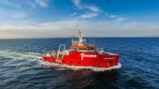
Fugro has finalized an agreement to acquire two platform supply vessels, namely Sea Goldcrest and Sea Gull, to be utilized as geotechnical assets. This strategic move reflects the company’s anticipation...
Combining the DriX uncrewed surface vehicle (USV) and the FlipiX remotely operated towed vehicle (ROTV), Exail has developed a unique solution enabling fully autonomous and remotely operated surveys. Combining the DriX uncrewed surface vehicle (USV) and the FlipiX remotely operated towed vehicle (ROTV), Exail has developed a unique solution enabling fully autonomous and remotely operated surveys. Accurate surveys...

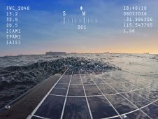
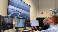
Fugro has completed its first fully remote offshore survey inspection in the North Sea for energy company TAQA. The project utilized the Blue Essence uncrewed surface vessel (USV) and the...
Anschütz, a leading expert in navigation and bridge systems, is making significant strides in the development of autonomous and onboard assistance systems for ships. As part of the Clean Autonomous...

Staff at Frontier Precision, USA, have been working hard to design and build a safe, affordable and reliable hydrographic surveying system that is simple to use, and easily deployed. The...
This site uses cookies. By continuing to use this website, you agree to our Cookies Policy. Agree