The renewal of a research vessel fleet
When contemplating the replacement of a research and survey fleet, a collective effort is required to meticulously curate an optimal new fleet, considering factors such as ship type, size, capabilities...

When contemplating the replacement of a research and survey fleet, a collective effort is required to meticulously curate an optimal new fleet, considering factors such as ship type, size, capabilities...
Fugro has secured the geophysical survey contract for the Dutch Doordewind offshore wind farm zone development. Fugro’s selection was driven by its pioneering 2D ultra-ultra-high resolution (UUHR) surveys, delivering unparalleled...

In the quest to unravel the mysteries beneath our planet’s water bodies, topobathymetric technologies emerge as a beacon of innovation. Among them, Lidar (light detection and ranging) and sonar sensors...
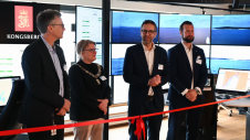
Autonomous vessel operations company Massterly has opened its Remote Operations Centre (ROC) in Horten, Norway. This significant step marks a crucial transition from the testing phase to fully-fledged operational capabilities...
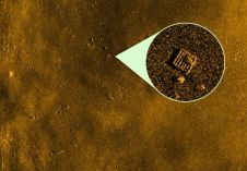
Kongsberg Discovery has unveiled a new analysis tool, developed in collaboration with underwater imaging specialist Cathx Ocean. This innovative tool significantly streamlines the process of detecting and classifying objects of...
Exail’s DriX uncrewed surface vessel (USV) recently completed a first-of-its-kind fisheries research survey to assess the impact on biomass and fish stock before, during and after wind farm construction. Equipped...

Amuse oneself Inc., established in 2011, develops hardware and software for 3D measurements required for ICRT technology (Information, Communication and Robot Technology). Since our successful commercialization of the world’s first...

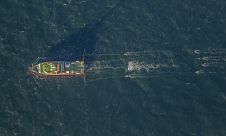
GEOxyz, a prominent European service provider specializing in marine site investigation, asset integrity and terrestrial survey, has revealed its newest addition to the fleet – the advanced offshore survey vessel...

Oceanology International 2024 (Oi24) is set to captivate attendees with a showcase of pioneering companies and innovative technologies, all poised to command attention at London's ExCeL. From advanced autonomous vehicles...

The presence of suspended sediments in water bodies presents significant challenges for the dredging industry. Existing methods to determine nautical depths are intrusive single point methods relying on in situ density or shear strength measurements1,3 or low-frequency single-beam echosounder recordings1,2. The use of single-beam echosounders is however systemically problematic as they are not practical in satisfying the CATZOC A1 coverages required for contemporary electronic navigational charting. The presence of suspended sediments in water bodies presents significant challenges for the dredging industry. Existing methods to determine nautical depths are intrusive single point methods relying on in situ...
This site uses cookies. By continuing to use this website, you agree to our Cookies Policy. Agree