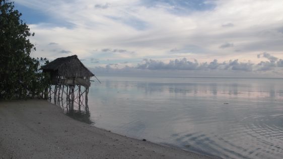
Navigating the rising tide
Experts are extremely concerned about the temperature of the Pacific Ocean, as the sea surface temperature this year was the warmest since satellite measurements began. This c...
Experts are extremely concerned about the temperature of the Pacific Ocean, as the sea surface temperature this year was the warmest since satellite measurements began. This c...
The US space agency NASA has successfully pushed the asteroid Dimorphos out of its original orbit in the universe, according to a recent announcement. The space rock was hit 11 mil...

In 1972, The Limits to Growth saw the light of the day, a report published by the Club of Rome. The message: to keep the Earth liveable, we must control economic growth. To think t...
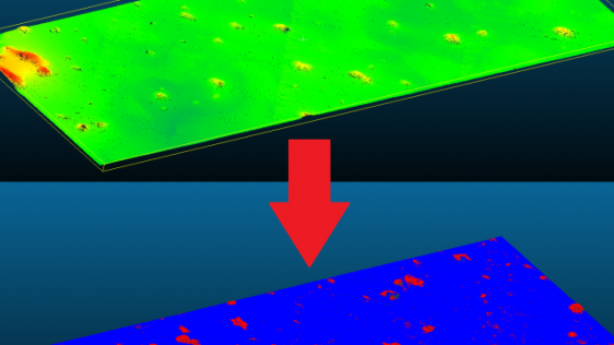
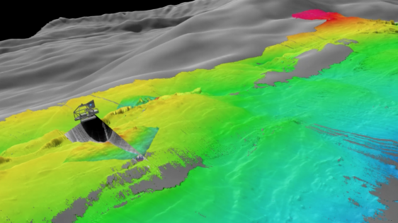
While online data acquisition is of course of the utmost importance in hydrography, technological developments mean that modern surveyors also need to know about data science, mach...

A few months ago I drew attention to the seizure of commercial vessels by armed groups from Somalia. Last year saw more than a hundred such attempts, a third ending in success for...
Your Hydro international this month carries the theme ‘safe navigation' - obvious, maybe, since Monaco is preparing for the 4th Extraordinary Hydrographic Conference (2nd to...
By Roosmarijn Haring Safety of navigation is essential for the protection of lives and the environment. This is the basic premise of the United Nations (1974) proclamat...
Working back then as an aeolian specialist in collaboration with marine scientists, I never could have guessed that 10 years later I would be the new editor-in-chief of H...
Do you still remember that for the first 10 years of Hydrointernational we had the columns ‘As it Was’ (by Admiral Steve Ritchie) and ‘As it Is’ (...
Maps can make the invisible visible – particularly relevant for hydrographic surveyors and geophysicists, who cannot see what they are surveying with the naked eye....
The Safety of Navigation subcommittee of the IMO’s Maritime Safety Committee (MSC) arrived at a consensus at their meeting last July (NAV’54) on a mandatory carriage f...
Two decades ago as CO of a survey ship, I interpreted the SSS-registrations (still on wet paper) twice. Once was for nautical charting purposes and the second, in my own time, was...
The UUV family has two separate branches: the ROV and AUV. Each branch has its pros and cons, and specific tasks. However, the application of AUV technology to ROVs – turnin...
When Admiral Steve Ritchie asked if he could retire (at the age of 92) on the 10th anniversary of Hydrointernational (February 2007), we stopped the column ‘As it Was’...
In my editorial in the March issue of Hydro International, I mentioned the inconsistency in certification of ship equipment in particular for ECDIS, where both the hardware and s...
The acronym ECDIS (Electronic Chart Display and Information System) has been in use for a good 15 years. The chart display part is getting more and more content (i.e. ENC coverag...
On behalf of the entire Hydrointernationalteam, I wish you a healthy and prosperous New Year. And to those readers who celebrate the start of a new year on a date other than 1st...
Ports and harbours vary in size, use and importance; for example, from relatively small local fishing ports to the really large international ports of major importance to internati...
If things go as planned, on 28 December 2005 the first satellite of the European Satellite Navigation System ‘Galileo’ will be launched (note: you have to be quite famous when they...
Inspection survey has a wide range of application, from preventive inspection to retrospective investigation of why or what happened. During the chain of events preceding an accide...
My first association with 'Surveys in extreme conditions', this issues theme, is surveying in the hostile cold of the Arctic or the Antarctic waters. However when talking to people...
Dredging in navigational channels, ports and harbours is intended to help the mariner navigate safely, with enough under-keel clearance. However, charting is not always uniform. To...
Under development since the 1980s, the completely revised chapter V (safety of navigation) of the Annex to the International Convention for the Safety Of Life At Sea (SOLAS) came i...
On behalf of the entire Hydro International team, I wish you a healthy and prosperous New Year. And to those readers who celebrate the start of a new year on a date other than 1st...
Almost every single shackle in the maritime transport chain must have a certificate of being trained or having been tested according to the requirements; for example, the container...
Hydrographic surveyors collect data for various purposes, e.g. for producing nautical charts. Most data are properly archived for future reference, while other data are just repres...
There is quite a difference between land surveyors (topographers) and those who survey at sea. Topographers can generally gather their information by direct observation and measure...
Almost a year ago (June 2005), Google Earth was launched and drew a lot of attention (‘fantastic’, ‘exciting’) both from the GI-specialists as from the general public. Google Earth...
On behalf of the entire Hydro international team, may I wish you a healthy and prosperous New Year. And to those readers who celebrate the start of a new year on a date other than...

This site uses cookies. By continuing to use this website, you agree to our Cookies Policy. Agree