Contract for Autonomous Underwater Vehicle
Marport has been awarded a contract valued at approximately CAD1 million to supply its SQX-1 Autonomous Underwater Vehicle (AUV) to an international geodetic survey company. Karl Kenny, CEO of Marport...
Marport has been awarded a contract valued at approximately CAD1 million to supply its SQX-1 Autonomous Underwater Vehicle (AUV) to an international geodetic survey company. Karl Kenny, CEO of Marport...
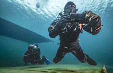
The innovative system facilitates map-based navigation for divers on a mission, offering the flexibility of seamless two-way communication between divers and the dive supervision team, as well as pre-mission and...

Autonomous underwater vehicles are becoming more and more common in the maritime industry, and technology is rapidly developing for different applications, such as inspection, maintenance and surveillance. Meanwhile, more advanced...

Ocean surveying and inspection specialist Argeo Subsea, CSI Nordics and Kongsberg Discovery have formalized a three-party Certificate of Delivery and Acceptance for an advanced HUGIN Superior AUV. This milestone agreement,...

Kongsberg Maritime has announced that Swire Seabed of Bergen, Norway has ordered a HUGIN AUV System configured for commercial survey applications. The Swire Seabed HUGIN AUV System is rated to...
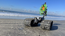
Bayonet Ocean Vehicles is set to showcase the Bayonet 250 autonomous underwater ground vehicle during its first UK demonstration at Ocean Business. The demonstration will highlight the vehicle’s autonomous capabilities,...
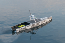
Autonomous vessel experts and artificial intelligence (AI) pioneers behind the first full-size unmanned research vessel to conduct scientific experiments while autonomously navigating the Atlantic Ocean have announced their plans to...

During a mission in the Northeast Pacific, Seaglider 144 propelled itself for 292 days, covering 5,528km (3,435 miles) through the water, more than half the pole to equator distance (or...

Geospatial cloud specialist north.io has announced it aims to revolutionize the modelling, collection and processing of ocean data using NVIDIA technologies. According to Jann Wendt, CEO, north.io, the synergy between...

By harnessing capabilities of advanced satellite technology and ever-evolving data analysis, satellite-based mapping (including satellite-derived bathymetry, SDB) offers an efficient, extensible and cost-effective method for mapping water properties, underwater topography...
This site uses cookies. By continuing to use this website, you agree to our Cookies Policy. Agree