The role of satellite-based mapping in hydrography
An efficient method for mapping water properties
By harnessing capabilities of advanced satellite technology and ever-evolving data analysis, satellite-based mapping (including satellite-derived bathymetry, SDB) offers an efficient, extensible and cost-effective method for mapping water properties, underwater topography and other elements of coastal zones and inland waters. This discussion prioritizes two critical applications of satellite-derived mapping – environmental monitoring and hydrographic planning – to demonstrate the flexibility of the technology and outline two distinct uses that may be relevant to a stakeholder’s needs in the maritime industry.
Most effective in nearshore and navigational area limit line (NALL) environments, satellite-based technology has been deployed in difficult-to-navigate or remote territories where data gaps persist and/or no environmental footprint is permitted. Strengths of the technology include the near-global ability to map large shallow-water areas, repeatedly if warranted, to provide modern hydrographic information at a fraction of the cost of a traditional airborne or shipborne survey without mobilization of equipment or personnel. Satellite-derived mapping is stated to provide results out to 30 metres depth in optically clear waters.
Satellite-based mapping and analysis hold immense promise for government hydrographers, intelligence agencies and organizations worldwide engaged in maritime navigational safety, updating bathymetric information, environmental conservation and coastal development planning. The diverse real-world implementations of SDB, from environmental monitoring to geospatial intelligence and including potential future applications, underscore its growing importance in a world that increasingly values modern, comprehensive bathymetric information.
Use case: environmental monitoring
Ecological observation and studies have become a well-established attribute of satellite-derived bathymetry’s ever-evolving science. As a crucial component of global marine ecosystem health, seagrass beds provide a multitude of ecosystem and nursery ground benefits. These include sediment bed stabilization, erosion prevention and the reduction of wave action during storms, carbon sequestration, water quality improvements through absorption, and biodiversity support (Coffer et al., 2023). Leveraging both hyperspectral and multispectral satellite-derived bathymetry workflows for the habitat observation and monitoring of this invaluable resource has proven to be quick and cost-effective.
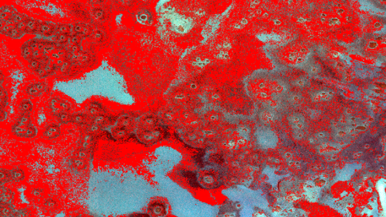
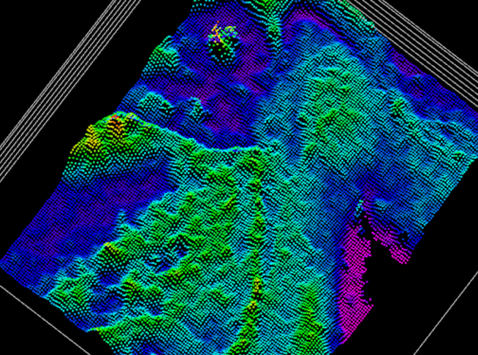
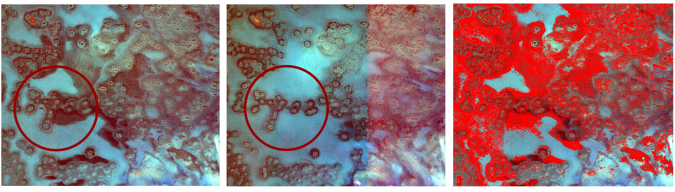
A seagrass bed analysis shown in Beneath the Waves highlights where TCarta provided environmental mapping services to identify seagrass extent and loss in three AOIs across the Greater Bahama Bank. Utilizing Maxar’s satellite imagery, detailed classifications of this area near the Ragged Islands in the Southern Bahamas were able to shed light on the density and quantity of vegetation present. One analysis performed at 30cm resolution with a calculation of the surface roughness of seagrass beds and another at 1.24m resolution using the differences in spectral response at differing depths were employed. To properly assess the surface roughness of seagrass beds versus coral reefs, 3D point cloud visualizations of the bathymetry were made. As seen in Figure 2, SDB of a seagrass bed shows the shape and density of seagrass beds compared to sand, rubble and coral reefs.
The introduction of surface roughness influenced by bathymetric ground-truth data allows this workflow to be trained to detect different densities and depths of seagrass. The Bahamas, with varying but known seafloor types and morphologies, allows for a quick classification without excess in situ data or other inputs to better train the model. This workflow seamlessly and economically detects habitat change and overall health of these cooperative submerged marine flowering plants.
Limitations may include sensor capture type and temporal influences such as weather, season, wave action, sea surface light refraction and false (deeper than actual bathymetric depth) returns due to a low albedo effect. However, these limitations are easy to leverage as training for future analyses due to the known benthic classifications and environmental conditions found in the area.
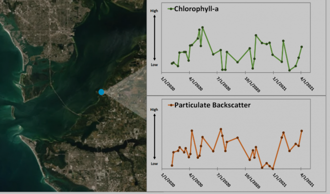
Another use case of TCarta’s environmental impact monitoring was leveraged by Sentinel-2 20m-resolution images collected from 8–13 April 2021 over the Piney Point discharge site in Port Manatee, Florida. The analysis indicated a slight increase in relative chlorophyll-a concentrations over previously derived measurements from January 2020, while particulate backscatter concentrations remained consistent with previous measurements. The increase in chlorophyll indicated that wastewater was at high enough concentrations to be measurable via satellite in Tampa Bay and/or the nutrient-laden wastewater had triggered an algal bloom. Using satellite-derived bathymetry, limitations of measuring such suspended sediments or nutrient blooms of microscopic algae give way to hurdles of accuracy regarding depth or quantifying density or amounts due to turbidity and a low albedo effect. After all, the darker the plume or submerged object is, the more light it will absorb.
Use case: hydrographic survey planning
Satellite-derived mapping technologies have long been promoted as an advanced reconnaissance tool and complementary technology to traditional hydrographic survey methods. Since a considerable amount of human and capital resources are required to execute a successful and accurate topobathy Lidar survey, single-beam sonar survey (SBES) or multibeam sonar survey (MBES), SDB and satellite-derived water quality can be deployed to improve the efficiency and effectiveness of hydrographic surveys.
Marine survey planning
In the planning stages of a shipborne survey, SDB has been used to plan more efficient survey track lines and avoid shallow, nearshore areas and hazards. It has also been used to pre-identify relevant ATONs (aids to navigation) and DTONs (dangers to navigation) required in surveys such as federal maritime charting surveys.
Airborne survey planning
In the case of planning an airborne Lidar survey (topobathy), SDB has been used to provide a generalized summary of depths within a project area, paving the way for planning and conducting feasibility studies for traditional bathymetric surveys to be undertaken, especially where inadequate chart data exists.
Beyond bathymetry, or depth information, advanced processing of satellite imagery can provide historical and modern water quality information that is relevant to planning survey priorities, including site selection and prioritization. Additionally, water quality information can be used to understand or document survey results. In a project delivered to Dewberry, survey planners and programme managers used TCarta’s Water Quality Dashboard to make flight decisions and plan resources and stage logistics (https://lidarmag.com/2023/12/31/mapping-florida-waters/).
In both marine and airborne surveys, SDB has proven useful post-survey for filling in data gaps, such as holidays or gaps between survey lines with respect to defined coverage, as well as confirming or fully mapping NALL-designated areas or gaps in depths to the zero-depth contour. The technological integration of SDB with traditional survey methods helps to leverage the strengths of each technology while mitigating the weaknesses. Often, these collaborations bring together ‘desk-top’ surveyors with hydrographic field surveyors, where both backgrounds are highly valued and impact on project success and efficacy.
Conclusion
Satellite-based observation methods are non-destructive and do not increase the carbon footprint compared to traditional in situ survey methods. From 13 July 1972 onward, satellites have traversed the globe, providing valuable insight into what is going on above and below the surface of our waters. This massive (and ever-growing) amount of data, spanning over 50 years, can be used to effectively map and monitor the health and biodiversity of various marine ecosystems, as well as to increase the safety and efficacy of traditional bathymetric surveys.
References
Megan M. Coffer et al. Providing a framework for seagrass mapping in United States coastal ecosystems using high spatial resolution satellite imagery, Journal of Environmental Management, Volume 337, 2023, 117669, ISSN 0301-4797, https://doi.org/10.1016/j.jenvman.2023.117669.

Value staying current with hydrography?
Stay on the map with our expertly curated newsletters.
We provide educational insights, industry updates, and inspiring stories from the world of hydrography to help you learn, grow, and navigate your field with confidence. Don't miss out - subscribe today and ensure you're always informed, educated, and inspired by the latest in hydrographic technology and research.
Choose your newsletter(s)


