AI set to improve job security in the marine survey sector
Embracing innovative technologies to meet growing demand
In a March 2023 blog, Microsoft founder, billionaire entrepreneur and philanthropist Bill Gates said: “The development of AI is as fundamental as the creation of the microprocessor, the personal computer, the internet and the mobile phone. It will change the way people work, learn, travel, get health care and communicate with each other. Entire industries will reorient around it. Businesses will distinguish themselves by how well they use it.”
New workflows that leverage artificial intelligence to achieve the same results as a human being but faster and cheaper will create job losses. From telemarketing to bookkeeping, there really is no stopping the ‘rise of the machines’. Job losses have already happened and there will be many more. However, AI replacing highly skilled workers – such as marine surveyors – is far less likely.
AI will certainly transform marine survey and other subsea sectors, but it cannot replicate the nuanced understanding and decision-making capabilities needed to acquire marine data efficiently. However, it will make the job easier and help surveyors to operate more effectively over a larger area, and it will take less time to acquire data than it used to. When used properly within an optimized workflow, from streaming the seafloor to producing the final geophysical product, AI will be responsible for massively improved operational efficiency. As a result, business performance and subsequent job security will improve too.
Lack of human resources
The use of AI to enhance marine data acquisition comes at a time when there are simply not enough available human skills and experience to go round, even with the graduate surveyors joining the industry. This has a lot to do with growth in the offshore wind sector, with new wind farms requiring significant amounts of bathymetric and sub-bottom data for planning and development. Furthermore, once a wind farm is up and running, it is common for the data to be updated at least once a year to ensure safety and inform operations & maintenance (O&M) regimes.
To put the size of the marine survey task into perspective, consider that the global offshore wind capacity is projected to rise from 34GW to 330GW this decade. This will drive the installation of more than 80,000 new fixed or floating moored turbines (based on an average capacity of 3.4MW). Each and every one of these turbines will depend on accurate and regularly updated seafloor data for its entire lifetime, which could easily be 30 years or more.
Such incredible growth in global wind energy production presents a fantastic opportunity for marine survey and related industries. But for survey businesses to transform demand for their services into revenue, they must have and be able to demonstrate their capacity to take on the new work, which is where innovative technology, including AI, will really make a difference.
Leveraging AI to meet demand
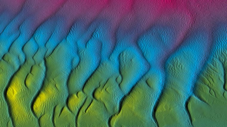
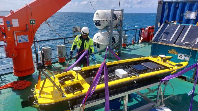
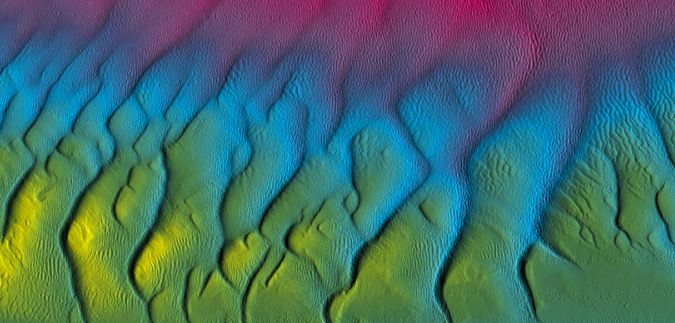
This is the objective behind the development of a new hands-free AI-powered data processing system for the GeoSwath 4 bathymetric sonar. In development since 2020 through an Innovate UK Knowledge Transfer Partnership between interferometric sonar manufacturer GeoAcoustics Ltd and the University of East Anglia, the new AI released this summer is one of the first to deliver fully automated processing of bathymetric data in real time and on board.
The AI saves time and money during a survey and at the post-processing stage by allowing a high-quality livestream of the seafloor via the GeoSwath 4 sonar. The new capability does not negate the need for a marine surveyor, however. What it does do is help the surveyor collect higher quality data in a more efficient manner. Because the ‘raw’ data is filtered with AI the instant it is received, surveyors can make better decisions with the improved information. It cuts out the ‘dirty work’, allowing professionals to focus on data quality and surveying efficiency.
This includes whether the acquired data is likely to meet IHO specs. By using the AI-powered Survey Accuracy function, surveyors can determine any data gaps within the survey and mitigate these while on the vessel, rather than back on shore in the office. Having the quality-controlled information instantly can therefore speed up the entire process, which reduces costs and frees up human resources to work on more projects. Considering the growing demand in the market being driven by offshore wind, such efficiencies lay the foundation for taking on more work than would be possible without the support of AI.
The streamlined AI-enabled workflow has environmental impacts too. Should the data not meet the quality threshold for a particular survey, the vessel can be directed to redo survey lines until the required quality is achieved before it heads home. Without this ability, a second trip to the site, using more fuel and costing more money, would normally be needed to address any issues found with the collected data back in the office.
The surveyor’s virtual co-pilot
Microsoft describes the use of AI as like having a co-pilot. Already available via the Edge browser, its AI can enhance general working, for example by helping with writing emails and managing inboxes. The term is even more fitting in the context of marine surveying, as data-processing AI can perform the role of a co-pilot for autonomous vessels. While the GeoSwath 4 AI is self-contained and applied solely to cleaning data in real time, there is potential in the long term for hydrographic sensor and instrument AI to communicate with the autonomy controllers that direct uncrewed marine survey platforms, whether on or below the surface.
Even when autonomous vessels become more commonplace, the gainful employment of marine surveyors will not be at risk. The vision is that autonomous surveying can streamline workflows to further speed up data acquisition and therefore reduce costs, while allowing the available human resources to be more centralized. The job spec may change, but demand for the same skills and experience in an operator or supervisor will be just as strong as it is without the highly evolved autonomous technologies of the future.
In fact, it is only in sci-fi set in the far future where humans are not in the ‘autonomy loop’. This is because, in today’s reality, nothing can replace the ability of a professional to make decisions based on their personal experience and ability to recognize the nuances at play in a given situation. It is interesting to see that in his blog, Bill Gates noted that: “they [AIs] also make factual mistakes and experience hallucinations.” AI is fallible, and it is easy to agree; anyone using generative AI such as ChatGPT in any depth, especially in technical matters, will soon find that its answers cannot be taken for granted and should not be trusted without verification.
GeoSwath 4 does not use the same type of generative approach as the new wave of online AI tools, and its clear focus ensures that it can be trusted to process data accurately. However, other AIs in the operational chain of autonomous marine surveying might need to make decisions that could affect both quality and safety. Human interaction and intervention will therefore always be needed, whether to address data, operational or navigational issues.
In closing, it is worth looking back in time. Subsea industry history shows that fear of robots taking over is unfounded. Take the case of remotely operated vehicles (ROVs). First used in the 1960s, there was considerable concern that divers would be put out of work by these strange new marine robots. But this never happened. Instead, underwater contractors developed a hybrid approach where the best aspects of divers and ROVs were used for the underwater inspection or repair jobs they are most suited to. Likewise, AI is very much suited to processing bathymetric data in real time, while marine surveyors are infinitely better at taking decisions, managing teams and acting on the bathymetric data received. This is why jobs in the marine survey sector will not be negatively impacted for decades, probably even centuries, to come. This only leaves the option to embrace AI, and enjoy the support of a tool that makes life easier and can in fact improve job security.
Read more
The Age of AI has begun, Bill Gates
https://www.gatesnotes.com/The-Age-of-AI-Has-Begun

Value staying current with hydrography?
Stay on the map with our expertly curated newsletters.
We provide educational insights, industry updates, and inspiring stories from the world of hydrography to help you learn, grow, and navigate your field with confidence. Don't miss out - subscribe today and ensure you're always informed, educated, and inspired by the latest in hydrographic technology and research.
Choose your newsletter(s)


