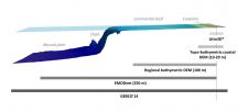
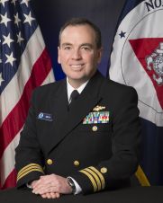
NOAA is one of the bigger organisations in the world that has surveying and charting in its portfolio. It’s an immense task as the USA has about 95,000 miles of coastline, important ports and a wide range of users – from recreational boaters to the biggest container vessels and tankers. The country also has to deal with environmental disasters like hurricanes and oil spills. NOAA is undergoing changes as the chart portfolio is ‘going digital’ and new initiatives such as using Maritime Autonomous Systems (MAS) for surveys. Hydro International interviews Capt Shep Smith, who generously gave an insight behind the scenes. NOAA is one of the bigger organisations in the world that has surveying and charting in its portfolio. It’s an immense task as the USA has about 95,000 miles of...