Mapping water column content during bathymetry surveys
Measuring suspended particulate matter in the water column is still a big challenge when it comes to covering large areas in the sea or rivers. A novel method to monitor particles...

Measuring suspended particulate matter in the water column is still a big challenge when it comes to covering large areas in the sea or rivers. A novel method to monitor particles...
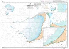
There is definite appeal to the concept of crowdsourced bathymetric data. But from where I sit as a National Hydrographer and nautical chart producer, the issues around using crowdsourced data...
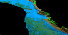
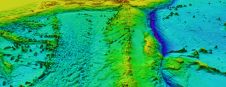
As part of a Catalan government project to improve the management of its marine environment, ICGC cooperated with Field to use airborne Lidar bathymetry (ALB) to survey the Catalan coastal...
Airborne Electro Magnetic Bathymetric (AEMB) mapping is useful in turbid and surf-zone waters where lidar systems are not fully effective. Coastal areas of hydrographic importance containing turbidity, shoals and channels...
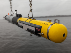
L3Harris, Voyis and Wavefront have joined forces to introduce cutting-edge technology aimed at enhancing the autonomous underwater vehicle (AUV) capabilities of the NATO Navy. L3Harris specializes in the development of...
At the 5th Extraordinary International Hydrographic Conference, held in Monaco in October 2014, the International Hydrographic Organization (IHO) agreed on the need to explore sources of bathymetric data outside traditional...
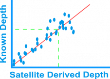
Bathymetry is traditionally acquired using singlebeam or multibeam echosounders. This method produces accurate depth measurements along transects but is constrained by operating cost and an inability to survey in very...
Great advancements have been made in three dimensional printing over the last few years and have made an impressionable impact across a variety of industries. 3D printings’ versatility can be...
ARGANS, a leading Earth observation company, has contributed a significant dataset of 8,000 square kilometres to The Nippon Foundation-GEBCO Seabed 2030 Project – the project seeking to inspire the complete...
Much has been said about Satellite Derived Bathymetry (SDB), but with the exception of SHOM, which led to the introduction of a number of SDB charts into the French chart...
This site uses cookies. By continuing to use this website, you agree to our Cookies Policy. Agree