UKHO and XOCEAN team up for uncrewed seabed survey
Marine data provider XOCEAN recently deployed five uncrewed surface vessels (USVs) near the Isles of Scilly to collect bathymetric data on behalf of the UK Hydrographic Office (UKHO). The USVs...
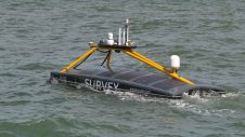
Marine data provider XOCEAN recently deployed five uncrewed surface vessels (USVs) near the Isles of Scilly to collect bathymetric data on behalf of the UK Hydrographic Office (UKHO). The USVs...
Aspect Land & Hydrographic Surveys Ltd is one of the leading independent coastal survey companies in the UK, with extensive experience and a proven track record in providing high-resolution hydrographic,...
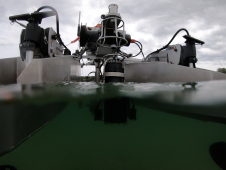
The National Oceanography Centre (NOC), working with the University of Southampton and the Department for Environment, Food and Rural Affairs (Defra), recently completed a Fully Autonomous Marine Protected Area Seafloor...
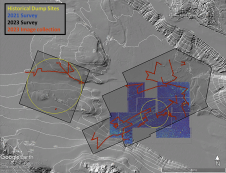
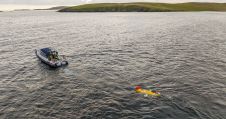
In a second seafloor survey off the Southern California coast, researchers from UC San Diego’s Scripps Institution of Oceanography uncovered a staggering 350 square kilometres of discarded military munitions. The April...

IHO standard S-44 is often used (or misused) to specify the quality of a hydrographic survey. While it is a useful tool, it is easy to misinterpret. One ‘misuse’ is...
HydroSurv, a prominent provider of electric and hybrid uncrewed surface vessels (USVs), has successfully secured Innovate UK funding to advance the commercialization of an end-to-end seagrass monitoring solution. This endeavour...

The Danish Geodata Agency, alongside several collaborators, is currently conducting trials on the latest iteration of navigational charts in the Baltic Sea region. This initiative forms part of an EU-funded...
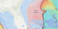
A groundbreaking study has unveiled the discovery of an immense coral reef on the bottom of the Atlantic Ocean, marking the largest deep-sea coral reef ever measured. Spanning approximately 26,000...
The esteemed Finnish Geospatial Research Institute (FGI) is set to utilize advanced Lidar systems developed by the Fraunhofer Institute for Physical Measurement Techniques IPM for future maritime surface surveys. Anticipating...
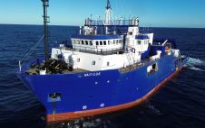
TDI-Brooks has strengthened its fleet with the RV Nautilus, a 75-metre DP2 vessel with enhanced capabilities that was built in 2000. This addition, which features the Geomil Manta-200 CPT system...
This site uses cookies. By continuing to use this website, you agree to our Cookies Policy. Agree