
Visualizing Korean seabed for marine space and ecosystem management
A machine learning-based seafloor classification project
Various attempts have recently been made to expand the scope of research in the maritime field through the convergence of cutting-edge technologies. One example is the remote classification and prediction of seafloor characteristics information through the application of machine learning technologies. Here, the authors introduce a machine learning-based seafloor classification project funded by the Ministry of Oceans and Fisheries of the Government of the Republic of Korea.
Seafloor characteristics information includes water depth, unique topography, seafloor properties and cover status, and ecological habitat, which provide comprehensive information related to the topography and environmental changes of the seafloor. This is essential information for marine spatial planning, management and conservation. Various intrinsic property information (texture, physical properties, geochemical properties, etc.) depends on the seafloor composition and contains additional, invisible, information about the seafloor. These characteristics can however be seen as unique acoustic characteristics using sound wave-based remote sensing data such as multibeam, chirp and sparker data. By establishing the correlation between the acoustic characteristics of remote sensing data and actual measurement data, it is possible to produce high-quality classification information on seafloor characteristics that exceeds the limitations of existing methods.
Following similar projects in Europe, the United States and Japan, artificial intelligence technologies were tried and tested for the remote classification of seafloor sediments using acoustic reflection data, with the final goal of developing classification techniques for surface seafloor sediments in wide areas.
Machine learning-based seafloor characteristics classification
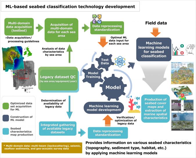
The large-scale project will receive approximately US$32.2 million of funding over five years, starting on 1 April 2022. The Korea Institute of Geoscience and Mineral Resources is the lead organization, with domestic universities, research institutes and private companies also involved in the project. The project scope includes: (1) the development of a machine learning dataset, (2) the development of learning model production technology, and (3) the production of a seafloor cover map and marine spatial characteristics.
The first step involves securing data optimized for AI learning through the acquisition of high-density multi-exploration data (remote sensing and actual measurement data) in the test area. The second step is to develop a learning model that improves the resolution of multiple exploration data and a learning model that interprets poor quality. The successful conversion of low-resolution to high-resolution images using deep learning technology was recently achieved. This makes underwater geological exploration with high-resolution exploration data and seafloor cover information possible by adapting the deep learning methods.
In addition, the backscattered data imaged in a wide area can be segmented into specific areas and the image vectorized for use as machine learning material, or to learn characteristic information classification by establishing correlations between points and ground truth data obtained at dense intervals. We can also create a model. It is of course essential to verify the applicability and performance of the learning model.
The last step is to create a composite cover information map. Here, the goal is to improve the usability of existing big data and build a visualization service system of seafloor information by producing a composite cover information map using legacy data (multibeam data acquired from the National Oceanographic Research Institute since 1996).
Expected results
The sea area around the Korean Peninsula undergoes severe topographical and underwater environmental changes from the continental shelf to the continental belt, and there are many variables to consider, such as acoustic devices, acquisition data processing and sound wave behaviour models. The issues that need to be resolved in this project include the establishment of regional characteristic information throughout the East Sea, Korea Strait and Yellow Sea around the Korean Peninsula. Considering the characteristics of sound wave behaviour, the diversity of seafloor topographical changes and the complexity of the seafloor environment, a process of gathering expert opinions and establishing technologies will be necessary through convergence and integration between multiple disciplines.
More information
https://www.gebco.net/documents/seabed2030_brochure.pdf
https://www.khoa.go.kr/eng/kcom/cnt/selectContentsPage.do?cntId=21040100
This article is contributed by the following authors:
Kiju Park, a researcher in the Marine Geology and Energy Division at KIGAM since 2014. He earned his Ph.D. in energy resources engineering from Pukyong National University in 2018.
Boyeon Yi, principal researcher in the Marine Geology and Energy Division at KIGAM since 2012. He received his Ph.D. in energy resources engineering from Pukyong National University in 2016.
Gong-gu Back, who assumed the role of director of KHRA Technology & Education Lab in 2022 after 30 years at KHOA.
Moonsoo Lim, principal researcher at Marine Research Corp. since 2019. He was awarded a Ph.D. in Applied Geology from Pukyong National University in 2018.
Eunmi Chang, CEO of Ziinconsulting and adjunct professor at the University of Seoul. She obtained her Ph.D. in Geography from the University of Kansas in 1997 and serves as the GEBCO SCOPE vice chair and Hysk vice chair.

Value staying current with hydrography?
Stay on the map with our expertly curated newsletters.
We provide educational insights, industry updates, and inspiring stories from the world of hydrography to help you learn, grow, and navigate your field with confidence. Don't miss out - subscribe today and ensure you're always informed, educated, and inspired by the latest in hydrographic technology and research.
Choose your newsletter(s)


