EOMAP to provide global shallow water bathymetry for Copernicus Marine Service
Coastal zones, situated at the intersection of land and ocean, hold immense social, economic and ecological significance. Currently, nearly 40% of the global population resides within 100km of the coast, and approximately three quarters of major cities are located along coastlines. These areas boast diverse ecosystems that store more carbon per unit area than forests. Despite their critical importance, there is a notable lack of comprehensive global knowledge and monitoring protocols.
In collaboration with Deltares and GGS Geo Consultancy (GGSgc), EOMAP, as the team lead, is addressing this knowledge gap by delivering global coastal bathymetric data. Bathymetry, which charts underwater topography, serves as a crucial environmental parameter for various coastal applications. These include modelling and hazard assessment, seafloor classification and the quantification of habitat loss or carbon storage capacity.
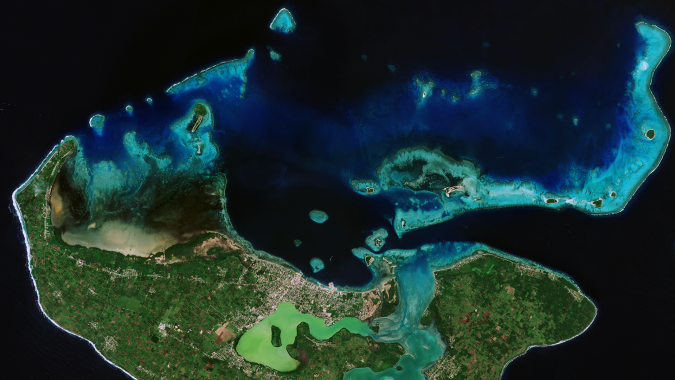
Nearshore bathymetry datasets
The Copernicus Marine Service implemented by Mercator Ocean International (MOi) prioritizes the development of a coastal extension to the service. The satellite-derived bathymetry (SDB) products to be developed for the Copernicus Marine Service starting with this contract will complement activities of EMODnet bathymetry. This is in line with the high-level agreement between the EU DG DEFIS and DG MARE for the coordination of activities between Copernicus Marine and EMODnet. “For knowledge-based decision-making on coastal issues, reliable open data that describes, monitors and forecasts the environment is key. Nearshore bathymetry datasets as delivered by this project strengthen the Copernicus Marine Service portfolio, as it will now provide better monitoring of coastal zones, maximizing the use of Copernicus Sentinel missions; this is one of the top priorities for the Copernicus Marine Evolution,” stated Angélique Melet, an oceanographer at MOi.
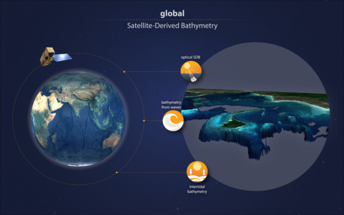
EOMAP as project lead will capitalize on its 20 years of expertise in SDB: “The project will combine multiple techniques to provide global shallow water bathymetry from satellite data. Our focus will be on optical bathymetry and that derived from wave kinematics,” explained Mona Reithmeier, project manager at EOMAP.
This will be complemented by intertidal bathymetry from the globally recognized Dutch knowledge institute for water and the subsurface, Deltares, and its established modelling know-how. “By integrating our trusted water-level modelling with an analysis of the comprehensive Sentinel-2 data archive, we’re pioneering global solutions for quality-assessed intertidal bathymetric data. This approach addresses the ever-growing need for consistent coastal mapping in both data-scarce and data-rich environments, providing crucial information to several applications such as morphodynamic modelling,” reported Etiënne Kras, an advisor and researcher in resilient ports & coasts at Deltares.
Merging different datasets
In view of the global scale of the project, George Spoelstra, the managing director of GGSgc, will add his international experience as an expert in marine cartography and bathymetry: “Working on a global dataset comes with several challenges: it not only requires scaling-up of data processing routines, but also merging different datasets and quality and coordinate systems. Luckily, we can build on our experience from the European EMODnet Bathymetry project which – in return – will benefit from the project results.”
The strong need for global ocean mapping is also addressed by The Nippon Foundation-GEBCO Seabed 2030 Project. As Jamie McMichael-Phillips, the director of Seabed 2030, stated: “We strongly support the objectives of the project, which is in line with the Seabed 2030 mission to deliver a complete map of the seabed.”
Apart from global bathymetry data, the MOi contract touches another challenging aspect: due to sediment movement, erosion or sand deposition, shorelines and underwater topography are changing constantly. This is why the team will also test satellite-based monitoring of morphodynamics in various coastal zones across the globe, preparing a roadmap for global monitoring routines.