Precision Lidar mapping of the Potomac River by USGS and Dewberry
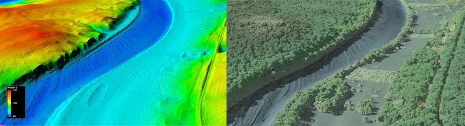
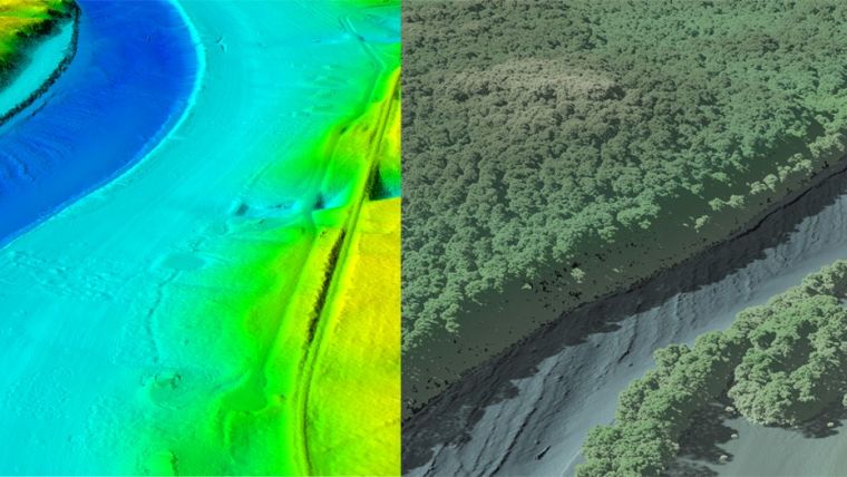
The US Geological Survey (USGS) and Dewberry have jointly released a new topobathymetric Lidar dataset for the Potomac River, extending from the Potomac Highlands in West Virginia to the Chesapeake Bay in Maryland, USA. Dewberry is a privately held professional services firm.
Conducted for the USGS’s 3D Elevation Program (3DEP), the Lidar survey involved collaboration with various stakeholders, including the USGS Earth Resources Observation and Science Center (EROS), National Geospatial Program (NGP) and Eastern Ecological Science Center (EESC) programmes, along with the Interstate Commission on the Potomac River (ICPRB).
Employing their Teledyne Optech CZMIL SuperNova Lidar system, Dewberry successfully surveyed a 55-mile (88.5km) stretch of the Potomac River, spanning from Hancock, MD to Shepherdstown, West Virginia. The survey resulted in the acquisition of 33km2 of submerged topobathymetric Lidar data. Project deliverables included a 3D point cloud and seamless topobathymetric digital elevation models (DEMs) for the surveyed river section. This project, the second for the Potomac River, builds on the first, which covered the area from Shepherdstown, West Virginia, to the Little Falls dam near Washington, DC. The generated maps are anticipated to serve as a valuable tool for predicting oil spill presence and movement in the Potomac River, supporting ICPRB’s mission to safeguard the waters and resources of the Potomac River basin through science, regional cooperation and education.
Bathymetric vertical accuracy
Emily Klipp, senior associate and senior project manager at Dewberry, expressed satisfaction with the outcomes, stating: “Given the depths, water conditions and bottom substrate of the Potomac River, we were hopeful we would get bottom returns with the enhanced CZMIL SuperNova system and couldn’t have been happier with the level of complete, seamless coverage achieved.”
The project specified an aggregate nominal point density (ANPD) of 1.5 points/m2 in shallow water (~1.5 x Secchi depth), a requirement exceeded by the survey, which delivered 6.25 points/m2. The topographic portion of the dataset adhered to ASPRS Positional Accuracy Standards for Digital Geospatial Data (2014) for a 10cm RMSEz Vertical Accuracy Class. Actual non-vegetated vertical accuracy was measured at 8.8cm (RMSEz), while bathymetric vertical accuracy was found to be 6.1cm (RMSEz), equating to ±12.0cm at the 95% confidence level.
Malek Singer, airborne product manager at Teledyne Geospatial, commended the success of Dewberry in producing high-detail topobathymetric data, stating: “I am very pleased to see the CZMIL SuperNova take on another challenging riverine environment, mapping its banks and bed with such high detail. Congratulations to Dewberry for this great success in topobathymetric data production!”