Robotics and deep learning to revolutionize seagrass monitoring
Employing innovative technology to protect vital ecosystems
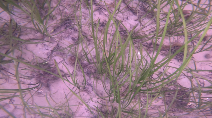
Seagrass meadows play an invaluable role as critical ecosystems that contribute significantly to marine biodiversity, carbon sequestration and coastal protection. In recent years, the importance of these underwater habitats has gained widespread recognition, and they have been increasingly studied and documented in ocean scientific research. Nevertheless, observation and monitoring remain significantly challenging and cost-intensive endeavours.
As a natural solution to combat climate change and protect against marine biodiversity loss, seagrass meadows contribute vital ecosystem services both to coastal communities and to society as a whole. Acting as nurseries to marine species, they offer shelter and food sources to fish and other marine organisms, purify seawater and stabilize the seabed, reducing the effects of coastal erosion. They are perhaps gaining most attention from scientists and policymakers for their ability to sequester carbon at rates surpassing terrestrial rainforests, making them a prime example of a nature-based solution to address climate change.
However, there is a significant obstacle standing in the way of developing protection and restoration schemes for these valuable ecosystems, and that is the sporadic and often incomplete observation evidence currently available to characterize and monitor meadow sites. Since today’s monitoring programmes remain heavily reliant on diver-based methods, spatial coverage and precision of repeatability are constrained, and labour-intensity inevitably puts pressure on the budgets available.
Fundamentally, knowledge gaps continue to hamper efforts to gather the essential evidence that informs planning and decision-making for protection and restoration. Consequently, stakeholders fail to reach the tipping points of scale where the value of the ecosystem services provided can be converted into fiscal mechanisms that provide the sustained funding needed to manage these important natural capital assets.
Enhancing our monitoring techniques, data collection and management processes is vital to facilitate effective conservation strategies, especially at a time when these invaluable natural assets are exposed to an array of environmental threats. Time is of the essence to deliver trusted, validated solutions to the practitioners who need them.
Non-invasive, budget-friendly robots
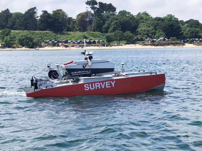
In October 2022, Hydro International published an article that featured the collaborative research and development work being undertaken by HydroSurv, working with the University of Plymouth and Valeport. Central to their approach was the deployment of small, battery-powered uncrewed surface vessels (USVs) as a non-invasive data acquisition platform capable of surveying wide spatial areas rapidly. At 2.8m long, HydroSurv’s REAV-28 is a multi-purpose vessel capable of rapid deployment and recovery from beaches and foreshores adjacent to work sites, with optimized sea-keeping for operations in the coastal environment and daywork endurance. Leveraging this platform to substitute the work performed by small workboats and divers has the potential to reduce CO2-equivalent emissions by up to 97%, while slashing the cost of project execution.
The USV was fitted with a payload that included the Valeport VA500 altimeter, typically used for precise underwater positioning on autonomous, remotely operated or towed underwater vehicles. This instrument was specifically selected for its advanced digital signal processing techniques. Using these techniques, the VA500 effectively filters out ambient noise and focuses on signal returns. Exclusively for this project, Valeport made custom modifications enabling acoustic profiles to be correlated at up to 10Hz.
Seagrass sites are generally found in shallow water, often at depths of less than eight metres. Because the survey areas are relatively shallow, selection of a single-beam unit represents the most practical balance between sufficient resolution and cost management. Importantly, the VA500 is positioned at a significantly lower price point than multibeam units.
A key component of the data processing was the use of deep learning algorithms developed by the University of Plymouth. SeagrassNet is a deep learning algorithm that employs recurrent neural network (RNN) techniques to detect and classify the presence of seagrass and the elevation and echo strength of the seagrass canopy, enabling a determination of relative density. This is made possible because, whereas the standard VA500 altimeter receives multiple signal echoes and must determine which echo corresponds to the seabed, the customized instrument used in this project provides the full echo response. All measured echoes along with their strength and sharpness are subsequently analysed in the processing algorithm.
Technology advancement in ground truthing and sediment analysis
While HydroSurv and the University of Plymouth have every confidence that their recent advances in the domain of submerged aquatic vegetation show significant potential to revolutionize seagrass monitoring, the project team has since gone beyond the state-of-the-art. With co-funding from Innovate UK and the Department for Environment, Farming & Rural Affairs (DEFRA), the partnership has further optimized the integrated robotic survey system to provide additional georeferenced, co-acquired datasets to further inform the health and environmental characteristics of seagrass sites.
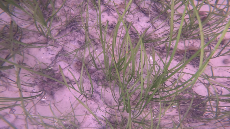
Significant upgrades have been made to the USV and its payload, including two new underwater camera systems and an advanced profiling winch. The first camera is a self-contained, high-resolution ground-truthing camera. Its purpose is to compare the acoustic ground discrimination data with precise, georeferenced photographic data, delivering an accurate visual reference to complement the processed acoustic data.
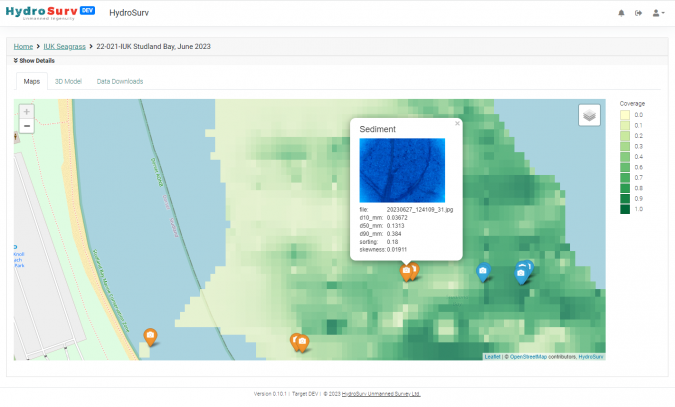
Additionally, a new sediment analysis camera, equipped with a macro lens, lands in direct contact with the seabed to capture detailed frame stills. These images are subsequently analysed using a digital grain size algorithm, integrated into the SeagrassNet application, allowing practitioners to classify the type of sediment present.
These new datasets, in conjunction with supplementary data from hull-mounted Valeport chlorophyll a and turbidity sensors, offer a more complete solution for comprehending and confirming the accuracy of our processed acoustic data. By incorporating these photographic datasets, it is possible to also obtain valuable insights into the condition of the seagrass and the suitability of the seabed sediment for restoration efforts. In the second year of fielding the technology system, the team has further improved the accuracy of the VA500 datasets by adding measurements from a hull-mounted Valeport sound velocity sensor.
To support these precise operations, HydroSurv has developed a new control application for the OSIL micro-profiling winch. Parameters for stand-off altitude, touchdown duration and speed can be configured for each camera system, including the ability to maintain the camera at a constant altitude underway. The use of the USV to perform this operation substitutes another operation that would otherwise be carried out by a workboat.
Actionable insight in the cloud
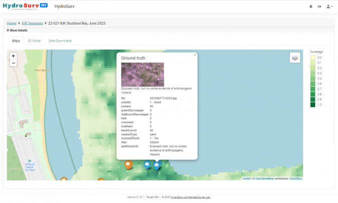
The aggregated datasets from the machine learning processing algorithms are hosted in HydroSurv’s ‘EasySurv’ application. This solution enables practitioners to determine seagrass biomass characteristics and assess carbon sequestration potential, which in turn facilitates planning of conservation and regeneration projects.
Since the use of robotics can significantly reduce resurvey intervals, the aim of the EasySurv application is to enrich the temporal comparison between datasets. Therefore, 2D heatmap comparisons for the seagrass metrics can be compared using drag-and-drop functionality, without the need for specialist GIS skills.
In the current DEFRA-funded project, the EasySurv application now shows the georeferenced ground-truth camera data as layers alongside the acoustic data and the sediment analysis data processed using the SeagrassNet machine learning toolchain. Ultimately, the aim has been to create a more accurate, efficient data processing pipeline to reduce reliance on expert data processors. By combining the automated data pipeline with affordable automated vessels, the project team hopes to democratize seagrass data and enable practitioner access to the data needed for natural capital assessment and monitoring.
The way forward: scale deployment
Significant development activity has been undertaken since the collaboration between the University of Plymouth and HydroSurv was initiated in 2021. From the outset, a well-defined, mutual vision to deliver a comprehensive, all-in-one solution was the foremost aim. In the DEFRA co-funded work of 2022, the project team was able to resurvey worksites on behalf of the Environment Agency that were originally surveyed under the previous project and other University of Plymouth research.
The next stage in the development roadmap is to scale deployment of the technology solution, to improve and demonstrate temporal comparison. To this end, HydroSurv is engaged with a range of stakeholders and has now configured large-scale pilot projects with three of these to field the system over an extended period.

Value staying current with hydrography?
Stay on the map with our expertly curated newsletters.
We provide educational insights, industry updates, and inspiring stories from the world of hydrography to help you learn, grow, and navigate your field with confidence. Don't miss out - subscribe today and ensure you're always informed, educated, and inspired by the latest in hydrographic technology and research.
Choose your newsletter(s)


