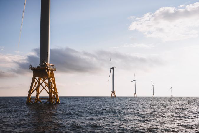
Offshore wind energy development, which is expanding rapidly along the East Coast of the United States, has the potential to play an important role in US efforts to combat the climate crisis and build a clean energy economy. In the north-east alone – historically a fishing area contributing to the economies of several coastal states and providing a livelihood for thousands of local fishermen – these wind farms will be spread across 2.4 million acres within the next ten years. The installation of fixed and floating turbines will have an effect on the ecology and biology of these areas, as well as on human activities (commercial and recreational fishing).
NOAA Fisheries Northeast Fisheries and Science Center (NEFSC) has been conducting research and monitoring to better understand the potential effects of offshore wind energy development on fish, shellfish, fisheries, protected resources and their ecosystems as well as to provide the US Bureau of Ocean Energy Management (BOEM) and other federal agencies, states, tribes and stakeholders with information on fisheries operations and the potential socio-economic impacts of offshore wind projects on fishing communities.
Observing and monitoring
As offshore wind farms will soon become an integral component of the New England seascape, novel, state-of-the-art methods will be required to survey and monitor the fish that reside in and migrate through these areas. Observing and monitoring the pelagic ecosystem can often be overshadowed by the demersal and benthic communities, yet it is a critical component of the life history of many commercially and ecologically important species. Limited capability to physically sample the biota with capture gear in and around offshore wind farms necessitates using complementary sampling methods to monitor the pelagic ecosystem. Active acoustic technologies, such as the Exail SeapiX multi-split-beam echosounder, make it possible to survey large areas quickly and efficiently and have a decades-long track record of mapping spatio-temporal distributions and estimate abundance and biomass.
Block Island Wind Farm survey
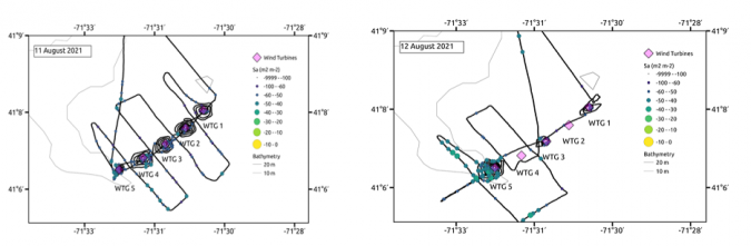
Exail collaborated with NOAA NEFSC on a four-day acoustic and biological survey of the Block Island Wind Farm – a five-turbine, 30MW wind farm located 6km off the coast of Rhode Island that has been operational since 2015 – to gain insight into the spatial distribution of fish species in and around the turbines using the SeapiX multibeam system.
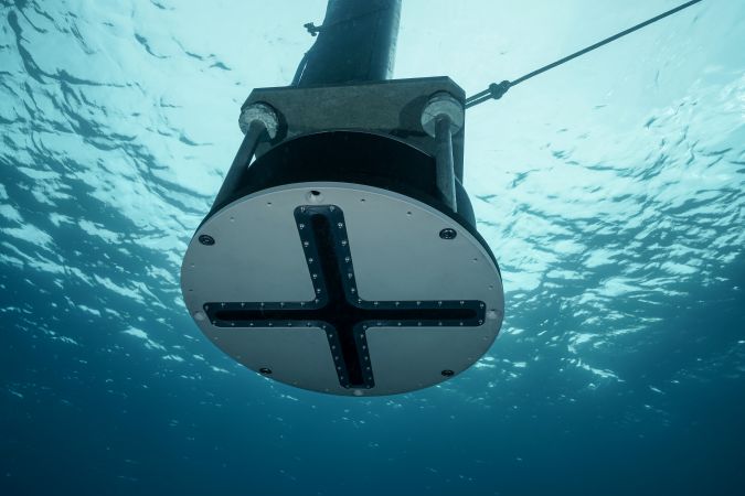
Designed and developed for fisheries research as well as commercial fishing, the SeapiX is a 150kHz solid state multi-split-beam sonar consisting of dual antennas in a symmetric Mills Cross architecture covering 2° x 120° on several swath.
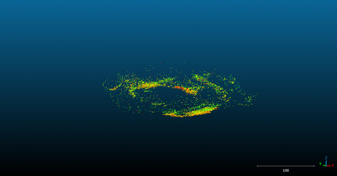
During the mission, the SeapiX sonar was pole-mounted on NOAA’s R/V Gloria Mitchell, a 72-foot (22m) stern trawler also outfitted with a hull-mounted, downward looking Simrad ES70, a 38/200kHz echosounder. The SeapiX was oriented both downward and sideways to characterize fish aggregation in middle and near surface waters in and around each turbine. A variety of survey designs were conducted, for instance spiral and straight line transect, to map 2D and 3D distribution. The volumetric acoustic data provided compatible data with historical fisheries data of fish aggregation sizes, shape, density and locations. The SeapiX can also estimate avoidance behaviour, which may significantly reduce measurement bias on stock estimates.
Fish were also collected using hook and line to verify the sources of acoustic backscatter and to measure length, sex and diet. It was determined that Black Sea bass (Centropristis striata) was the most commonly caught species and appeared to be the primary constituent of the fish aggregation mapped by the acoustic systems.
The acoustic data was also analysed in reference to the turbines to investigate utilization of the turbines and/or surrounding areas as habitat. Data was also collected during the day (first three days) and night hours (final day) to obtain pilot data on the spatial and temporal distributions in and around the turbine structures.
The SeapiX sonar, given its frequency range, allows for safe operation in the wind farm areas and offers sufficient resolution to observe animals very close to the turbine structures.
Conclusion
This Block Island Wind Farm survey operation represents the first step in NOAA’s plan to observe and understand fish distributions in a wind farm and to provide answers to the underlying scientific questions on whether wind farm turbines have an aggregation or repulsive effect on biomass, or no effect at all. In the absence of ‘before’ data, it is impossible to offer a definitive conclusion. However, the preliminary conclusions from this study suggest that these structures enhance abundance at the scale of individual turbines but do not have an effect on the biomass on the scale of the wind farm area.
The next step in this study requires surveying a future wind farm construction site, and planning is currently underway to conduct a survey using the SeapiX sonar integrated on Exail’s DriX uncrewed surface vehicle.
Guillaume Matte, R&D manager for SeapiX at Exail commented: “It was a fantastic opportunity to run these tests together with NOAA experts. Marine renewable energy installations require specific assessment surveys to qualify their impact on biomass, and we believe that SeapiX adds real value to this application. It offers a more insightful experience for fish detection and mapping and provides valuable information on fish behaviour as well. We are grateful to the NOAA fishery scientists on-board during this survey for their discerning conversations and for sharing their enthusiasm about SeapiX.”
“SeapiX expanded our ability to map fish distribution in and around turbines and was a great complement to the traditional single-beam echosounder”, added Michael Jech, research fisheries biologist at NEFSC.