
Fugro Marinestar measures GNSS satellite orbit and clock corrections for GPS, GLONASS, Galileo and BeiDou. These corrections are sent over six geostationary L-band satellites and over internet and can be used to calculate highly accurate positions in real time. MarinestarG4+ position accuracy has continuously improved over the years, and here we present the performance of the Marinestar service in 2022.
Marinestar can be used by the following (and more) GNSS receivers: Fugro 9205, Septentrio AsteRx-Marine, AsteRx4 OEM, AsteRx-m3 Marine, AsteRx-U3 Marine, Trimble SPS, MPS and BD/BX series, Applanix POS MV, SBG, Norbit and Kongsberg DPS 110/112, 3610, 3710
Global static positions
The position performance is measured daily at around 130 places in the world. The global 95% height position performance is shown on the world map below for January 2022.
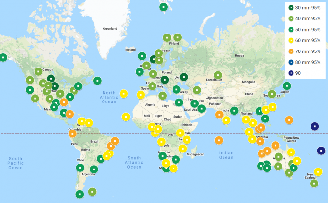
As can be seen, the 95% height accuracy is around 5cm in Europe, northern Asia, Chile, Argentina and southern Australia. In the equatorial zone, tropical rain reduces the results to 6–7cm, and accuracy is slightly more than 10cm over the Pacific Ocean. Dynamic accuracy is at the same level as the above static results.
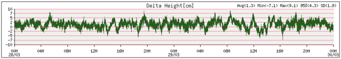
Static position over time
The standard deviation of the height is 1.9cm, and 95% of the height measurements are within 4.3cm. The horizontal offset is within 1.9cm for 95% of the positions. On average, 32 GNSS satellites were used.
The value of “+”
Plus is used if at least one GNSS satellite has its integer number of wavelengths fixed, which improves the position accuracy to the centimetre level. Using one year of global “+” data improved the 95% height accuracy by 1cm. The “+” corrections also remove small residual orbit and clock errors.
IMPROVEMENTS USING FOUR CONSTELLATIONS
Using four GNSS constellations (GPS, Galileo, BeiDou and Glonass) has several advantages over using single or dual satellite constellations for the Marinestar service.
GPS
GPS typically has 31 useable satellites around the globe. In January 2020, G11, G22 and G28 were unavailable, reducing the minimum number of available satellites temporarily to 28. For users in the field, the minimum number of available GPS satellites in this period was six. This is close to the minimum number of four satellites for GPS-only Marinestar positioning.
BeiDou3
BeiDou3 has 42 healthy satellites using the B1 and B3 frequencies. BeiDou inclined and geostationary satellites at 36,000km are accurate at the metre level and provide support when going under bridges or during short periods of radio interference. There are around 27 useable BeiDou satellites over China and between 7 and 12 over the Americas.
Galileo
Galileo typically has four to nine satellites available during the day worldwide. When E19 became unhealthy, this was reduced to a minimum of just three Galileo satellites useable in parts of the world. The December-launched E10 and E34 will soon become healthy, improving Galileo satellite availability. The accuracy level of orbit and clocks offsets is in the same order as for GPS.
Glonass
Glonass currently has 24 satellites, but R6, R10 and R23 (no L2) and R11 and R16 (unhealthy) are currently unavailable, reducing the number of useable Glonass satellites to just two during short periods of the day. Glonass orbit and clock offsets are in the order of three times less accurate than for GPS and Galileo.
It is clear that all four constellations (G4) increase availability. In general, there are between 25 and 40 GNSS satellites available for Fugro Marinestar positioning. Using four constellations also helps in the following cases:
- Blockage of the sky
If a survey vessel needs to map the sea bottom of a harbour near quays where large ships are moored, a large part of the sky can be blocked. More GNSS satellites increases the ability to continue precise positioning. - Radio interference
Radio interference can be due to local electronic devices accidentally transmitting at higher harmonics in the GNSS bands. Also, GPS L1 Jammers are quite common. In large parts of the world, amateur radios can use the 1,240–1,300MHz band, interfering with Glonass L2, BeiDou B3 and Galileo E6. Iridium and Globalstar at 1,602MHz can interfere with Glonass L1 and GPS L1 if the GNSS antenna has no bandwidth protection. - Scintillation
During ionospheric storms, the ions in parts of the upper atmosphere can move so fast that tracking of GNSS signals gets difficult. This is called scintillation. Scintillation around the equator – in particular near Brazil – and in the Arctic regions reduces the number of useable satellites in parts of the sky. Having more GNSS satellites helps to overcome resets and reduce position noise, especially as solar activity increases to a solar maximum in around 2025.
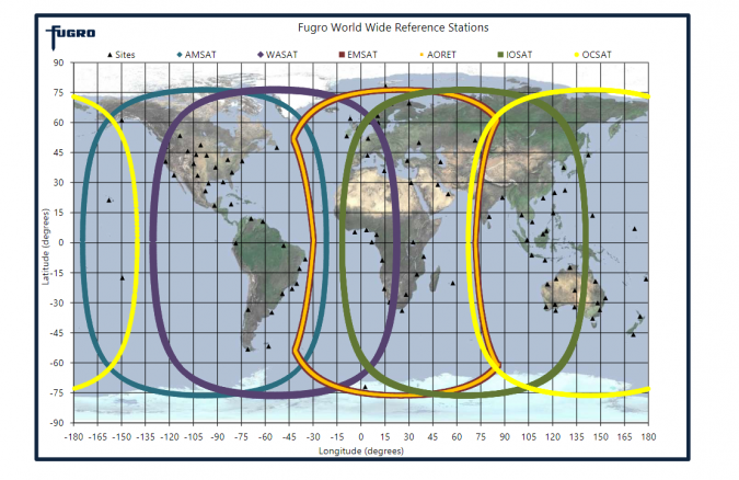
Automatic L-band beam selection
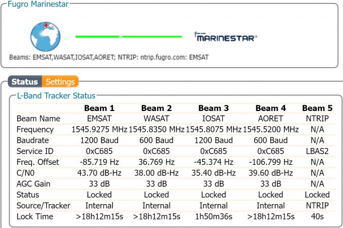
The AsteRx-Marine M3 with the Marinestar service tracks four correction beams over L-band and two internet NTRIP (Networked Transport of RTCM via Internet Protocol) correction streams. In many places in the world, there are two (Americas, India, Asia, Australia) to four (Europe, Africa, Middle East) L-band satellites visible. The receiver automatically selects the best available correction beam.
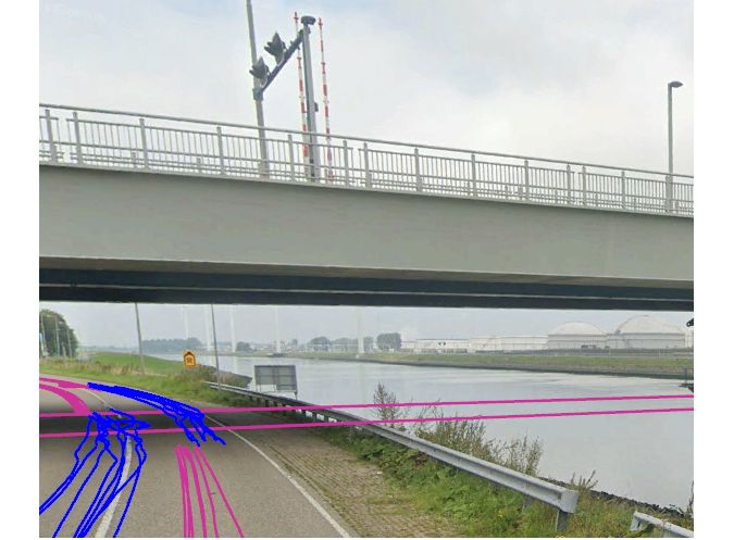
Bridging gaps
A test can be carried out by driving slowly 14 times backwards and forwards underneath a bridge to establish the time required to recover to original accuracy. If MarinestarG4+ loses lock on all GNSS satellites, for example when passing under a bridge or with heavy GNSS L1 radio interference, the receiver can acquire the original position accuracy within 8–10 seconds after passing the bridge. The maximum period without GNSS measurements after which the position can be restored is more than one minute.
Conclusions
- Vertical and horizontal accuracies for the Marinestar service are better than 5cm (95%).
- During bridging periods without GNSS measurements, Marinestar is capable of acquiring the original position accuracy within 8–10 seconds.
- Multiple L-band/NTRIP input increases the robustness and availability of corrections, while using more GNSS satellites improves the accuracy and robustness of the position solution.
For more information contact Fugro Marinestar
Europe +31 (0)70 317 0960
[email protected]