
A competition was launched by the UK’s Defence Science and Technology Laboratory (DSTL) in an effort to develop an autonomous survey vehicle that could survey rivers and river banks to find sites for troops to cross. Ultrabeam met the challenge.
Map the Gap: Creating an Autonomous Marine Survey Vehicle to Find River Crossing Points
The solution leverages Applanix technology, including POS MV and Applanix POSPac Mobile Mapping Suite, an industry-leading software for direct georeferencing of mobile mapping sensors using GNSS and inertial technology, to blend GNSS data with angular rate and acceleration data from an IMU and heading from GAMS to produce a robust and accurate solution.
Overview
Ultrabeam Hydrographic was awarded one of five contracts by the Ministry of Defence – Defence and Security Accelerator (DASA) to develop a remotely operated reconnaissance survey system to help troops safely and stealthily advance into enemy territory across water obstacles such as rivers.
Challenge
When advancing into enemy territory, the UK military needs to be able to cross obstacles such as rivers. Currently, the only way to identify suitable crossing points is to send Royal Engineer reconnaissance troops to survey both banks of the river. This exposes them to danger in the battlefield and risks compromising the location by signalling interest in it.
The goal is to remove personnel from this potentially dangerous and compromising task using a semi-autonomous remote system that will be able to take measurements without needing personnel at the location.
While there are currently sensors that can take the needed measurements, plus a variety of delivery platforms, there is not a combined system to gather all of the required data.
Solution
Five small and medium-sized businesses were awarded Phase 1 funding (£177,789) by the DASA, to fast-track their innovative solutions and test with the British Army.
Ultrabeam Hydrographic was one of the companies awarded the contract to demonstrate an amphibious, autonomous hydrographic survey vehicle, using novel techniques, tools, sonar and Lidar. To design the perfect solution, Ultrabeam selected Applanix.
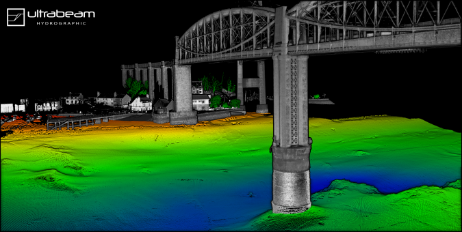
Ultrabeam created a rugged eight-wheeled, unmanned vehicle that is three metres long, fully amphibious, and boasts electric thrusters for advanced in-water manoeuvrability. The vehicle has an ultra-high resolution 360-degree coverage scanner, a Norbit Multibeam system, and the Applanix POS MV OceanMaster system (Position and Orientation System for Marine Vessels) for directly georeferencing the data collected. This data can then be used to create very high accuracy maps of the terrain, both above and below the waterline.
“All of our high-accuracy surveys use POSPac to post-process the POS MV files to provide the highest accuracy solution possible. We deploy a Trimble base station as close to the site as possible and log base data at 1Hz. We then use this base station to post-process the POS data to produce the SBET for import into our survey processing software QPS Qimera,” says Gabriel Walton.
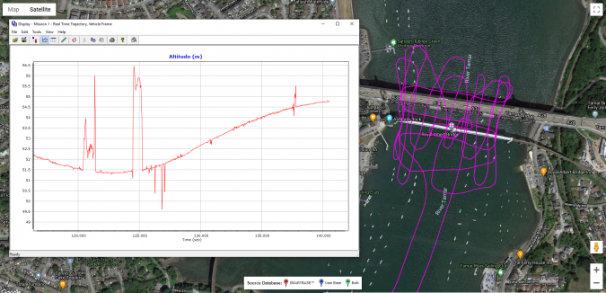
The vehicle also has a portable control station, mobile command centre and real-time 3D navigation and data display.
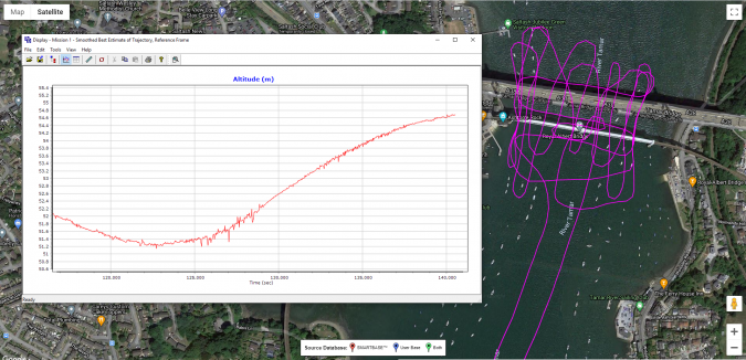
“POSPac greatly improves the navigation solution, allowing us to increase our accuracy. We perform bridge surveys and close passes to high quay and port walls, which reduces our view of the satellites. Errors are often visible in the real-time solution, but once POSPac’d we improve the final solution,” says Gabriel.
Ultrabeam will be participating in Phase 2 of Map the Gap and will use this as part of its fleet moving forward.
Trust your position with Applanix
Learn more about Applanix POS MV
Learn more about Applanix POSPac