A Farewell to Times Past
We have all enjoyed the column entitled ‘As it Was’, contributed since the very first issue of Hydro international by Admiral Steve Ritchie. The piece has always been very much...
We have all enjoyed the column entitled ‘As it Was’, contributed since the very first issue of Hydro international by Admiral Steve Ritchie. The piece has always been very much...
Global warming, climate change, rising sea levels and increased commercial exploitation of the seabed and sea space are important global indicators of a changing world environment. A crucial role is...
He started his career as a meteorologist, became head of the computer section of the ‘Deutsches Hydrographisches Institut’ (DHI) in 1970 and was responsible for IT affairs, which brought him...
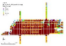
Merrick & Company was awarded a US$345,000 contract to deliver raw and processed LIDAR data, 2-foot contours, and a DEM for 1650 square miles of Stearns County, Minnesota and a...
The Remote Systems & ROV Division Management Committee and Contracts Workgroup of the International Marine Contractors Association (IMCA) working with Stronachs Solicitors of Aberdeen, have prepared the recently published "Contract...
The Turkish Navy’s Department of Navigation, Hydrography and Oceanography (TN-DNHO) is responsible for surveying, charting and supporting the navigational safety of Turkish waters covering more than 8,000km of Turkish coastline...
Bathymetric data has traditionally been important for producing nautical charts in support of safe navigation. Hazardous environmental conditions and technological restraints have, however, limited the ability to acquire near-shore data....
Jack Dangermond is the co-founder and president of ESRI, a privately held geographic information systems (GIS) software company that is headquartered in Redlands (CA, USA). In 1969, he co-founded ESRI...
We investigated the most significant issues affecting the creation of a littoral zone digital elevation model from overlapping bathymetric and topographic Lidar (light detection and ranging) data. The main challenge...
The requirements for hydrographic surveys influence the specifications adopted. Requirements, however, are not static. For example, emerging requirements now include collecting hydrographic data for the potential impacts of tsunami modelling,...
This site uses cookies. By continuing to use this website, you agree to our Cookies Policy. Agree